IMAGES TAKEN NEAR TO
Welland Close, SLOUGH, SL3 8UZ
Introduction
This page details the photographs taken nearby to Welland Close, SL3 8UZ by members of the Geograph project.
The Geograph project started in 2005 with the aim of publishing, organising and preserving representative images for every square kilometre of Great Britain, Ireland and the Isle of Man.

There are currently over 7.5m images from over14,400 individuals and you can help contribute to the project by visiting https://www.geograph.org.uk
Image Map
Images are licensed for reuse under creativecommons.org/licenses/by-sa/2.0
Notes
- Clicking on the map will re-center to the selected point.
- The higher the marker number, the further away the image location is from the centre of the postcode.
Image Listing (37 Images Found)
Images are licensed for reuse under creativecommons.org/licenses/by-sa/2.0
Image
Details
Distance
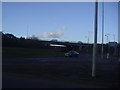
1
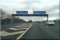
M4 westbound
At junction 5 for the A4.
Image: © Robin Webster
Taken: 7 Jan 2018
0.05 miles

4
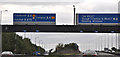
Slough District : M4 Motorway
The M4 Motorway as it passes Junction 5.
Image: © Lewis Clarke
Taken: 26 Oct 2014
0.08 miles
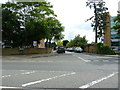
5
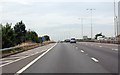
M4 westbound at Junction 5
Passing over the roundabout of junction 5.
Image: © Julian P Guffogg
Taken: 7 Aug 2013
0.11 miles
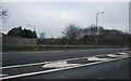
7
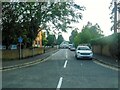
Colnbrook : Hill Rise
A road off London Road.
Image: © Lewis Clarke
Taken: 12 Sep 2020
0.13 miles
9
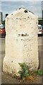
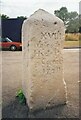
Old Milestone (East Face), A4, London Road, Slough
The milestone is located at the Langley traffic island south of M4/A4 junction 5, in the tarmac on the centre refuge of the eastern entrance, on the south side of the road. Parish of Slough (Slough District). Carved stone post, Bath Road limestone diamond, erected by the Colnbrook, Datchet & Slough turnpike trust in the 18th century. For the other face, see https://www.geograph.org.uk/photo/6626653
Inscription reads:- : SLOUGH / 2 : : LONDON / 18 : : COLNBROOK / 1 : : XVIII / Miles fr(om) / Hyde P(ark) Corner / 1741 :
Carved benchmark (cancelled) on lower right face.
Grade II Listed, List Entry Number: 1113383
https://historicengland.org.uk/listing/the-list/list-entry/1113383
Milestone Society National ID: BU_LB18
Image: © A Rosevear & J Higgins
Taken: 9 Jul 2001
0.13 miles
10
Old Milestone (South West Face), A4, London Road, Slough
The milestone is located at the Langley traffic island south of M4/A4 junction 5, in the tarmac on the centre refuge of the eastern entrance, on the south side of the road. Parish of Slough (Slough District). Carved stone post, Bath Road limestone diamond, erected by the Colnbrook, Datchet & Slough turnpike trust in the 18th century. For the other face, see https://www.geograph.org.uk/photo/6626646
Inscription reads:- : SLOUGH / 2 : : LONDON / 18 : : COLNBROOK / 1 : : XVIII / Miles fr(om) / Hyde P(ark) Corner / 1741 :
Carved benchmark (cancelled) on lower right face.
Grade II Listed, List Entry Number: 1113383
https://historicengland.org.uk/listing/the-list/list-entry/1113383
Milestone Society National ID: BU_LB18
Image: © A Rosevear & J Higgins
Taken: 9 Jul 2001
0.13 miles