IMAGES TAKEN NEAR TO
Trelawney Avenue, SLOUGH, SL3 8RQ
Introduction
This page details the photographs taken nearby to Trelawney Avenue, SL3 8RQ by members of the Geograph project.
The Geograph project started in 2005 with the aim of publishing, organising and preserving representative images for every square kilometre of Great Britain, Ireland and the Isle of Man.

There are currently over 7.5m images from over14,400 individuals and you can help contribute to the project by visiting https://www.geograph.org.uk
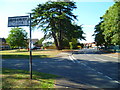
Image Map
Images are licensed for reuse under creativecommons.org/licenses/by-sa/2.0
Notes
- Clicking on the map will re-center to the selected point.
- The higher the marker number, the further away the image location is from the centre of the postcode.
Image Listing (8 Images Found)
Images are licensed for reuse under creativecommons.org/licenses/by-sa/2.0
Image
Details
Distance
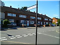
1
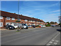
Langley - Trelawney Avenue
Terrace housing on residential road junction with Parry Green North.
Image: © James Emmans
Taken: 25 Mar 2017
0.11 miles
5
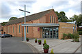
Holy Family Catholic Church, Trelawney Avenue, Langley
Image: © MrC
Taken: 20 Jul 2013
0.20 miles
6
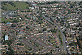
Langley : Aerial Scenery
From a plane that had taken off from Heathrow, looking down to Langley.
Image: © Lewis Clarke
Taken: 20 Aug 2016
0.21 miles
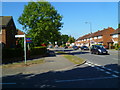
7
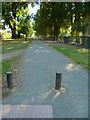
Looking south from Reddington Drive along an avenue to the A4
Image: © Shazz
Taken: 4 Sep 2013
0.24 miles
8
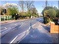
Pedestrian-Controlled Traffic Lights on Langley Road
Langley, also known as Langley Marish, is a large village 2 miles to the east of central Slough. Since the end of World War II, it has become contiguous with Slough and could now be regarded as a suburb.
Image: © David Dixon
Taken: 11 Apr 2015
0.25 miles