IMAGES TAKEN NEAR TO
London Road, SLOUGH, SL3 8QG
Introduction
This page details the photographs taken nearby to London Road, SL3 8QG by members of the Geograph project.
The Geograph project started in 2005 with the aim of publishing, organising and preserving representative images for every square kilometre of Great Britain, Ireland and the Isle of Man.

There are currently over 7.5m images from over14,400 individuals and you can help contribute to the project by visiting https://www.geograph.org.uk
Image Map
Images are licensed for reuse under creativecommons.org/licenses/by-sa/2.0
Notes
- Clicking on the map will re-center to the selected point.
- The higher the marker number, the further away the image location is from the centre of the postcode.
Image Listing (26 Images Found)
Images are licensed for reuse under creativecommons.org/licenses/by-sa/2.0
Image
Details
Distance
1
Pie and Chips & Car Wash
The white building does burgers, pies, fish & chips etc. The yard is used for vehicle washing.
Image: © Des Blenkinsopp
Taken: 6 Nov 2017
0.03 miles
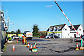
3
A failed development
On the Colnbrook by-pass, I think the plan was for a hotel.
Image: © Fernweh
Taken: 29 May 2015
0.06 miles
4
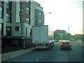
Colnbrook : Colnbrook By-Pass A4
Looking along Colnbrook By-Pass.
Image: © Lewis Clarke
Taken: 12 Sep 2020
0.07 miles
6
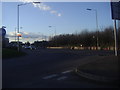
Roundabout at the end of Colnbrook Bypass
Image: © David Howard
Taken: 19 Feb 2012
0.11 miles
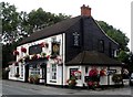
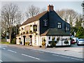
7
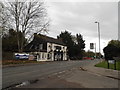
Colnbrook High Street at the junction of Crown Meadow
Looking towards the Queen Anne pub
Image: © David Howard
Taken: 2 Nov 2014
0.11 miles
8
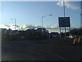
Roundabout on Colnbrook Bypass and London Road
Image: © David Howard
Taken: 19 Feb 2012
0.11 miles
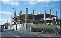
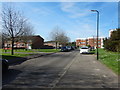
10
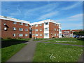
Colnbrook - Crown Meadow
Flats close to The Queen Mother Reservoir.
Image: © James Emmans
Taken: 25 Mar 2017
0.12 miles