IMAGES TAKEN NEAR TO
Mead Avenue, SLOUGH, SL3 8JE
Introduction
This page details the photographs taken nearby to Mead Avenue, SL3 8JE by members of the Geograph project.
The Geograph project started in 2005 with the aim of publishing, organising and preserving representative images for every square kilometre of Great Britain, Ireland and the Isle of Man.

There are currently over 7.5m images from over14,400 individuals and you can help contribute to the project by visiting https://www.geograph.org.uk
Image Map
Images are licensed for reuse under creativecommons.org/licenses/by-sa/2.0
Notes
- Clicking on the map will re-center to the selected point.
- The higher the marker number, the further away the image location is from the centre of the postcode.
Image Listing (10 Images Found)
Images are licensed for reuse under creativecommons.org/licenses/by-sa/2.0
Image
Details
Distance
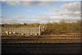
1

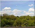
Railway at Langley
Seen from a passing train in the sidings at Langley are the Balfour Beatty-liveried class 20 locomotives No. 20142 and 20189. These will be used in connection with the forthcoming electrification of the Great Western Main Line.
Image: © Gareth James
Taken: 15 Jun 2014
0.14 miles
4
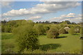
Maplin Park, Langley
This pleasant park, seen from the Meadfield Road entrance, is close to the north eastern corner of Langley.
Image: © Richard Vince
Taken: 6 Apr 2013
0.21 miles
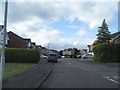
7
Bend in Meadfield Road, Langley
At its junction with Meadfield Avenue (left foreground), Meadfield Road swings sharply at right angles to head east towards the edge of Langley. At the same time, the motley collection of Edwardian style houses (see Image) gives way to more modern and uniform looking homes.
Image: © Richard Vince
Taken: 6 Apr 2013
0.24 miles
9
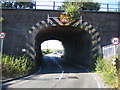
Langley: Chequer Bridge
An accident waiting to happen here (and probably has on numerous occasions in the past) with a narrow low bridge, and a blind approach from this side at least, as the bridge allows traffic on Market Lane to pass under the main line railway to/from London Paddington. The bridge is between Langley and Iver railway stations.
Image: © Nigel Cox
Taken: 18 Jul 2006
0.25 miles
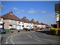
10
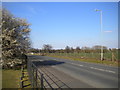
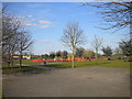
Market Lane, Langley
Market Lane marks the eastern edge of Langley for some distance south of the Great Western main line (whose embankment can just be glimpsed behind the trees in the distance). At this point, the houses on the west side of the road are interrupted by Maplin Park, an open space with play area, in which the photographer is standing. To the east is farmland.
Image: © Richard Vince
Taken: 6 Apr 2013
0.25 miles