IMAGES TAKEN NEAR TO
High Street, SLOUGH, SL3 8HF
Introduction
This page details the photographs taken nearby to High Street, SL3 8HF by members of the Geograph project.
The Geograph project started in 2005 with the aim of publishing, organising and preserving representative images for every square kilometre of Great Britain, Ireland and the Isle of Man.

There are currently over 7.5m images from over14,400 individuals and you can help contribute to the project by visiting https://www.geograph.org.uk
Image Map
Images are licensed for reuse under creativecommons.org/licenses/by-sa/2.0
Notes
- Clicking on the map will re-center to the selected point.
- The higher the marker number, the further away the image location is from the centre of the postcode.
Image Listing (22 Images Found)
Images are licensed for reuse under creativecommons.org/licenses/by-sa/2.0
Image
Details
Distance
1
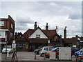
Harrow Hall
Former public house on High Street, Langley.
Image: © JThomas
Taken: 23 May 2022
0.01 miles
2
Rite Price, Langley
I agree with the proprietor here. It's time the ridiculous silent "gh" was dropped from English spelling.
Tho' I'm not sure how successful he'll be so near to Slou.
Image: © Des Blenkinsopp
Taken: 14 Mar 2013
0.02 miles
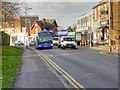
3
Harrow, Goodbye
Yet another closed pub.
Image: © Des Blenkinsopp
Taken: 14 Mar 2013
0.02 miles
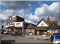
4
High Street Langley
Langley, also known as Langley Marish, is a large village 2 miles to the east of central Slough. Since the end of World War II, it has become contiguous with Slough and could now be regarded as a suburb.
Image: © David Dixon
Taken: 11 Apr 2015
0.02 miles
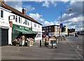
5
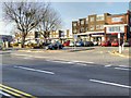
Langley Shopping Precinct
Langley, also known as Langley Marish, is a large village 2 miles to the east of central Slough. Since the end of World War II, it has become contiguous with Slough and could now be regarded as a suburb.
Image: © David Dixon
Taken: 11 Apr 2015
0.03 miles
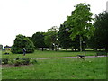
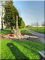
7
Langley Village War Memorial
Langley, also known as Langley Marish, is a large village 2 miles to the east of central Slough. Since the end of World War II, it has become contiguous with Slough and could now be regarded as a suburb.
The War Memorial, at the northern point of Image], was erected after the end of the 1914-18 Great War.
Image: © David Dixon
Taken: 11 Apr 2015
0.04 miles
8
The War Memorial, Langley
Langley, also known as Langley Marish, is a large village 2 miles to the east of central Slough. Since the end of World War II, it has become contiguous with Slough and could now be regarded as a suburb.
The War Memorial, at the northern point of Image], was erected after the end of the 1914-18 Great War.
Image: © David Dixon
Taken: 11 Apr 2015
0.04 miles
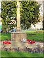
9
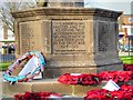
Langley War Memorial (detail)
Langley, also known as Langley Marish, is a large village 2 miles to the east of central Slough. Since the end of World War II, it has become contiguous with Slough and could now be regarded as a suburb.
The War Memorial, at the northern point of Image], was erected after the end of the 1914-18 Great War.
"This memorial was erected and the adjoining field acquired in memory of Langley men who gave their lives in The Great War 1914 - 1919. Their name liveth for evermore"
Image: © David Dixon
Taken: 11 Apr 2015
0.04 miles
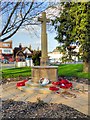
10
War Memorial and the Memorial Ground, Langley
Langley, also known as Langley Marish, is a large village 2 miles to the east of central Slough. Since the end of World War II, it has become contiguous with Slough and could now be regarded as a suburb.
The War Memorial, at the northern point of Image], was erected after the end of the 1914-18 Great War.
Image: © David Dixon
Taken: 11 Apr 2015
0.05 miles