IMAGES TAKEN NEAR TO
Burroway Road, SLOUGH, SL3 8EH
Introduction
This page details the photographs taken nearby to Burroway Road, SL3 8EH by members of the Geograph project.
The Geograph project started in 2005 with the aim of publishing, organising and preserving representative images for every square kilometre of Great Britain, Ireland and the Isle of Man.

There are currently over 7.5m images from over14,400 individuals and you can help contribute to the project by visiting https://www.geograph.org.uk
Image Map
Images are licensed for reuse under creativecommons.org/licenses/by-sa/2.0
Notes
- Clicking on the map will re-center to the selected point.
- The higher the marker number, the further away the image location is from the centre of the postcode.
Image Listing (9 Images Found)
Images are licensed for reuse under creativecommons.org/licenses/by-sa/2.0
Image
Details
Distance
1
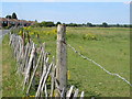
Field off Market Lane, Langley
This square is almost entirely taken up by fields which separate Langley from Richings Park. Despite this being green belt, repeated attempts have been made to develop this land for housing, thus far unsuccessful.
Image: © Darren Smith
Taken: 10 Jul 2005
0.11 miles
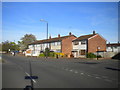
4
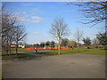
Maplin Park, Langley
This pleasant park, seen from the Meadfield Road entrance, is close to the north eastern corner of Langley.
Image: © Richard Vince
Taken: 6 Apr 2013
0.16 miles
6
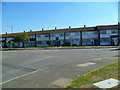
Parlaunt Road at the junction of Market Lane
Image: © David Howard
Taken: 11 May 2014
0.18 miles
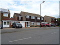
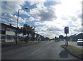
7
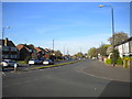
Looking east along Parlaunt Road from Heron Drive
Image: © Shazz
Taken: 4 Sep 2013
0.19 miles
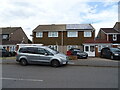
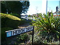
8
Parlaunt Road, Langley
Looking east from the junction with Tamar Way.
Image: © Richard Vince
Taken: 4 May 2016
0.24 miles