IMAGES TAKEN NEAR TO
Langley Road, SLOUGH, SL3 8BP
Introduction
This page details the photographs taken nearby to Langley Road, SL3 8BP by members of the Geograph project.
The Geograph project started in 2005 with the aim of publishing, organising and preserving representative images for every square kilometre of Great Britain, Ireland and the Isle of Man.

There are currently over 7.5m images from over14,400 individuals and you can help contribute to the project by visiting https://www.geograph.org.uk
Image Map
Images are licensed for reuse under creativecommons.org/licenses/by-sa/2.0
Notes
- Clicking on the map will re-center to the selected point.
- The higher the marker number, the further away the image location is from the centre of the postcode.
Image Listing (56 Images Found)
Images are licensed for reuse under creativecommons.org/licenses/by-sa/2.0
Image
Details
Distance
1
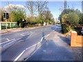
Pedestrian-Controlled Traffic Lights on Langley Road
Langley, also known as Langley Marish, is a large village 2 miles to the east of central Slough. Since the end of World War II, it has become contiguous with Slough and could now be regarded as a suburb.
Image: © David Dixon
Taken: 11 Apr 2015
0.03 miles
2
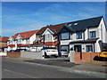
Langley - Langley Road
Newly renovated semi-detached houses. The house on the right has got new style windows and side extension and large porch.
Image: © James Emmans
Taken: 25 Mar 2017
0.09 miles
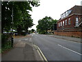
4

Langley Village Centre
Langley is still known by locals as "Langley Village", but after the war it merged with Slough to become its eastern suburb. This is the centre of Langley, known as "The Harrow" after the nearby pub. The sign on the roundabout was erected to commemorate the millennium.
Image: © Darren Smith
Taken: 9 Jul 2005
0.17 miles
5
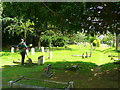
Churchyard maintenance.
A team of strimmer operatives are at work at St. Mary's this afternoon.
Image: © Jonathan Billinger
Taken: 19 Jun 2008
0.20 miles
6
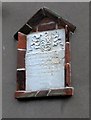
Foundation tablet, Kederminster Almshouses, Langley
This stone is built into the wall above the porch of the almshouses, and commemorates the endowment of the houses by Sir John Kederminster, giving the date, 1617. At the top are the arms of the Kederminster family - this part is in much better condition than the rest and must have been renewed. Below is a Latin inscription, badly weathered. I can make out the words 'Manerii de Langly ma . . . et Wyrardisbury' (the old form of 'Wraysbury') and - I think - 'Dachet'. The family name 'Kederminster' appears at the top. Just below it is the word 'Senescalis', which I suspect may be the word for 'almshouse'. (In Stamford, Lincolnshire, various old almshouses go by the name of 'Callis'.)
At the very bottom the date is given in two forms, linked by a big curly bracket - 'A Dni 1617', and above it the so-called 'regnal date', 'Regni 15', meaning the 15th year of the reign of James I.
I ought to say that this is my own attempt at deciphering the inscription, and I'm hoping that someone with local knowledge may be able to make better sense of the whole thing.
Image: © Stefan Czapski
Taken: 15 Mar 2011
0.21 miles
7
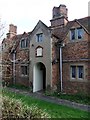
The Kederminster Almshouses, Langley Marish: the porch
The central porch of these early-17th century almshouses. This is the north-facing side of the building, seen here from the churchyard. The tablet over the entrance carries an inscription, but is quite badly weathered. I could make out little other than that the language is Latin, and the date - A.D. 1617.
For a general view of the almshouses see http://www.geograph.org.uk/photo/2309292
Image: © Stefan Czapski
Taken: 15 Mar 2011
0.21 miles
8
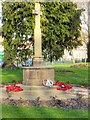
Langley Village War Memorial
Langley, also known as Langley Marish, is a large village 2 miles to the east of central Slough. Since the end of World War II, it has become contiguous with Slough and could now be regarded as a suburb.
The War Memorial, at the northern point of Image], was erected after the end of the 1914-18 Great War.
Image: © David Dixon
Taken: 11 Apr 2015
0.22 miles
9
The War Memorial, Langley
Langley, also known as Langley Marish, is a large village 2 miles to the east of central Slough. Since the end of World War II, it has become contiguous with Slough and could now be regarded as a suburb.
The War Memorial, at the northern point of Image], was erected after the end of the 1914-18 Great War.
Image: © David Dixon
Taken: 11 Apr 2015
0.22 miles
10
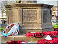
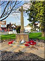
Langley War Memorial (detail)
Langley, also known as Langley Marish, is a large village 2 miles to the east of central Slough. Since the end of World War II, it has become contiguous with Slough and could now be regarded as a suburb.
The War Memorial, at the northern point of Image], was erected after the end of the 1914-18 Great War.
"This memorial was erected and the adjoining field acquired in memory of Langley men who gave their lives in The Great War 1914 - 1919. Their name liveth for evermore"
Image: © David Dixon
Taken: 11 Apr 2015
0.22 miles