IMAGES TAKEN NEAR TO
Hurricane Way, SLOUGH, SL3 8AG
Introduction
This page details the photographs taken nearby to Hurricane Way, SL3 8AG by members of the Geograph project.
The Geograph project started in 2005 with the aim of publishing, organising and preserving representative images for every square kilometre of Great Britain, Ireland and the Isle of Man.

There are currently over 7.5m images from over14,400 individuals and you can help contribute to the project by visiting https://www.geograph.org.uk
Image Map
Images are licensed for reuse under creativecommons.org/licenses/by-sa/2.0
Notes
- Clicking on the map will re-center to the selected point.
- The higher the marker number, the further away the image location is from the centre of the postcode.
Image Listing (22 Images Found)
Images are licensed for reuse under creativecommons.org/licenses/by-sa/2.0
Image
Details
Distance
1

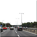
Car Park and Warehouse, Axis Park
Looking NW from Sutton Lane Bridge over the M4.
Image: © Des Blenkinsopp
Taken: 6 Nov 2017
0.03 miles
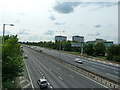
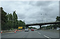
2
M4 Motorway Eastbound
Approaching the Sutton Lane Bridge
Image: © Geographer
Taken: 28 Jun 2015
0.07 miles
3

Slough : M4 Motorway
The M4 Motorway between Junction 5 (Langley Roundabout) and Junction 4B (Thorney).
Image: © Lewis Clarke
Taken: 23 Mar 2018
0.08 miles
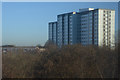
5
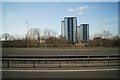
Longwood Park Flats
As seen from the M25 - Common Road, Langley.
Image: © Fernweh
Taken: 6 Apr 2013
0.10 miles
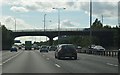
6

M4 bridge carries Sutton Lane
From the look of the map the original track of Sutton lane has been modified to make this motorway crossing.
Image: © Stuart Logan
Taken: 24 Aug 2011
0.12 miles
8
On the eastbound M4 at the Sutton Lane bridge
Image: © Rob Purvis
Taken: 13 Aug 2021
0.12 miles
9
Slough : Apartment Blocks
Looking towards a block of flats at Axis Park in Slough.
Image: © Lewis Clarke
Taken: 5 Jan 2017
0.12 miles
