IMAGES TAKEN NEAR TO
Boxall Way, SLOUGH, SL3 7UG
Introduction
This page details the photographs taken nearby to Boxall Way, SL3 7UG by members of the Geograph project.
The Geograph project started in 2005 with the aim of publishing, organising and preserving representative images for every square kilometre of Great Britain, Ireland and the Isle of Man.

There are currently over 7.5m images from over14,400 individuals and you can help contribute to the project by visiting https://www.geograph.org.uk
Image Map
Images are licensed for reuse under creativecommons.org/licenses/by-sa/2.0
Notes
- Clicking on the map will re-center to the selected point.
- The higher the marker number, the further away the image location is from the centre of the postcode.
Image Listing (3 Images Found)
Images are licensed for reuse under creativecommons.org/licenses/by-sa/2.0
Image
Details
Distance
1
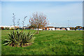
Two Cricket Fields
This is quite a large cricket club, with space for two games to go on side by side. New houses come right up to the boundary. Crash. Tinkle. Six!
Image: © Des Blenkinsopp
Taken: 30 Oct 2017
0.09 miles
2
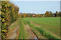
Field on the edge of Slough
All the neighbouring open space is either country park or sports facilities. This is just an ordinary field. You can almost feel the developers peering through the hedge.
Image: © Des Blenkinsopp
Taken: 30 Oct 2017
0.11 miles
3
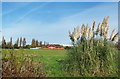
Cricket Ground between the Parks
Two areas of old parkland, Upton Court Park and Ditton Park, are separated by this cricket ground and an arable field. Houses have crept up to the fence line all around them. An established sports facility like this might be able to hold them off, but the field looks an easy target.
Image: © Des Blenkinsopp
Taken: 30 Oct 2017
0.17 miles