IMAGES TAKEN NEAR TO
Cockett Road, SLOUGH, SL3 7TQ
Introduction
This page details the photographs taken nearby to Cockett Road, SL3 7TQ by members of the Geograph project.
The Geograph project started in 2005 with the aim of publishing, organising and preserving representative images for every square kilometre of Great Britain, Ireland and the Isle of Man.

There are currently over 7.5m images from over14,400 individuals and you can help contribute to the project by visiting https://www.geograph.org.uk
Image Map
Images are licensed for reuse under creativecommons.org/licenses/by-sa/2.0
Notes
- Clicking on the map will re-center to the selected point.
- The higher the marker number, the further away the image location is from the centre of the postcode.
Image Listing (85 Images Found)
Images are licensed for reuse under creativecommons.org/licenses/by-sa/2.0
Image
Details
Distance
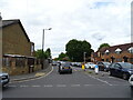
1
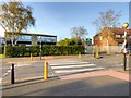
Pedestrian Crossing on Trelawney Avenue
Image: © David Dixon
Taken: 11 Apr 2015
0.15 miles

3

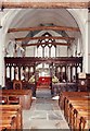
St. Mary the Virgin Church, Langley
The church dates from about 1150, and benefited from expansion by the Kederminster family in the 17th century, a local family who owned much of the land in Langley Marish.
Image: © Darren Smith
Taken: 10 Jul 2005
0.19 miles
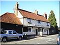
4
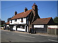
Langley Marish: The Red Lion
On the west side of St Mary's Road opposite the Church is this public house, built in the 16th century by the Church (!) to provide money for church repairs and for the original rectory that formed part of the church.
Image: © Nigel Cox
Taken: 18 Jul 2006
0.19 miles
5
The 'Red Lion', at Langley Marish
Langley Marish is now pretty much part of Slough, but there is a little huddle of buildings at the old village centre: the church, the 'Red Lion' opposite, and two rows of 17th century almshouses. What caught my eye at the 'Red Lion' was its weatherboarded outbuilding - neatly tarred and showing how smart weatherboarding can look when well looked after. And just look at that 'catslide' roof !
Image: © Stefan Czapski
Taken: 15 Mar 2011
0.20 miles
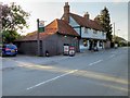
7
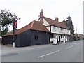
The Red Lion Pub, Langley
St Mary's Road, Langley, Slough, SL3 7EN close to the Slough Arm of the Grand Union Canal
Image: © canalandriversidepubs co uk
Taken: 5 Feb 2010
0.20 miles
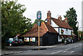
8
The Red Lion, Langley
Langley, also known as Langley Marish, is a large village 2 miles to the east of central Slough. Since the end of World War II, it has become contiguous with Slough and could now be regarded as a suburb.
Image: © David Dixon
Taken: 11 Apr 2015
0.21 miles
9
Langley : "Red Lion" public house
Grade II listed - https://historicengland.org.uk/listing/the-list/list-entry/1135748?section=official-list-entry.
Image: © Jim Osley
Taken: 1 Sep 2022
0.21 miles