IMAGES TAKEN NEAR TO
Cedar Way, SLOUGH, SL3 7JT
Introduction
This page details the photographs taken nearby to Cedar Way, SL3 7JT by members of the Geograph project.
The Geograph project started in 2005 with the aim of publishing, organising and preserving representative images for every square kilometre of Great Britain, Ireland and the Isle of Man.

There are currently over 7.5m images from over14,400 individuals and you can help contribute to the project by visiting https://www.geograph.org.uk
Image Map
Images are licensed for reuse under creativecommons.org/licenses/by-sa/2.0
Notes
- Clicking on the map will re-center to the selected point.
- The higher the marker number, the further away the image location is from the centre of the postcode.
Image Listing (7 Images Found)
Images are licensed for reuse under creativecommons.org/licenses/by-sa/2.0
Image
Details
Distance
1
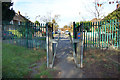
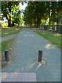
Gate out of Ditton Park
The footpath and cycleway (national cycle route 61) leave Ditton Park into Cedar Way, Langley.
Image: © Des Blenkinsopp
Taken: 30 Oct 2017
0.06 miles
2
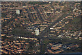
Slough : Town Scenery
Looking down from a plane which had just taken off from Heathrow Airport.
Image: © Lewis Clarke
Taken: 5 Jan 2017
0.11 miles
3
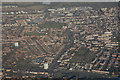
Slough : Suburb Scenery
Looking down into the town of Slough from a passing plane.
Image: © Lewis Clarke
Taken: 5 Jan 2017
0.11 miles
4
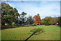
Kedermister Park
The park is mainly playing fields, but the eastern end has a few more trees. The park is named after Sir John Kedermister, a local 17th century nobleman. https://armorial.library.utoronto.ca/content/kedermister-john
Image: © Des Blenkinsopp
Taken: 30 Oct 2017
0.16 miles
5
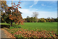
Leaves in Ditton Park
An autumn scene.
Image: © Des Blenkinsopp
Taken: 30 Oct 2017
0.17 miles
6
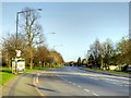
Looking south from Reddington Drive along an avenue to the A4
Image: © Shazz
Taken: 4 Sep 2013
0.17 miles