IMAGES TAKEN NEAR TO
James Meadow, SLOUGH, SL3 7GE
Introduction
This page details the photographs taken nearby to James Meadow, SL3 7GE by members of the Geograph project.
The Geograph project started in 2005 with the aim of publishing, organising and preserving representative images for every square kilometre of Great Britain, Ireland and the Isle of Man.

There are currently over 7.5m images from over14,400 individuals and you can help contribute to the project by visiting https://www.geograph.org.uk
Image Map
Images are licensed for reuse under creativecommons.org/licenses/by-sa/2.0
Notes
- Clicking on the map will re-center to the selected point.
- The higher the marker number, the further away the image location is from the centre of the postcode.
Image Listing (33 Images Found)
Images are licensed for reuse under creativecommons.org/licenses/by-sa/2.0
Image
Details
Distance
1
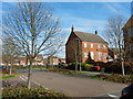
Langley - James Meadow
Large modern traditional style housing estate.
Image: © James Emmans
Taken: 25 Mar 2017
0.02 miles
2
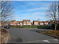
Langley - James Meadow
Open area in middle of the estate.
Image: © James Emmans
Taken: 25 Mar 2017
0.03 miles
3
Langley, James Meadow
Langley, also known as Langley Marish, is a large village 2 miles to the east of central Slough. Since the end of World War II, it has become contiguous with Slough and could now be regarded as a suburb.
Image: © David Dixon
Taken: 8 Apr 2015
0.03 miles

5
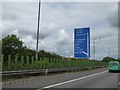
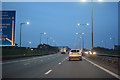
Final sign for M4 junction 5 eastbound
The green screens prevent some dazzle from night-time traffic on the adjacent road
Image: © David Smith
Taken: 30 May 2017
0.11 miles
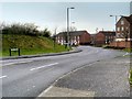
6
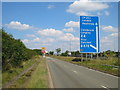
M4 Exit Sliproad at Junction 5 (Langley)
Langley, also known as Langley Marish, is a large village 2 miles to the east of central Slough. Since the end of World War II, it has become contiguous with Slough and could now be regarded as a suburb.
Image: © David Dixon
Taken: 8 Apr 2015
0.12 miles
7
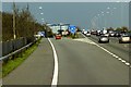
Windsor and Maidenhead : M4 Motorway
The M4 Motorway between Junction 6 (Tuns Lane) and Junction 5 (Langley Roundabout).
Image: © Lewis Clarke
Taken: 23 Mar 2018
0.12 miles
8
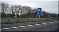
Ditton Road, near Langley
This square contains part of the Queen Mother Reservoir in the south, and fields to the north. The Ditton Road links Datchet with Langley, and runs alongside the M4 as can be seen here.
Image: © Darren Smith
Taken: 10 Jul 2005
0.13 miles
10
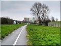
Langley, Path at the side of Major's Farm Road
Image: © David Dixon
Taken: 8 Apr 2015
0.16 miles