IMAGES TAKEN NEAR TO
Springate Field, SLOUGH, SL3 7DH
Introduction
This page details the photographs taken nearby to Springate Field, SL3 7DH by members of the Geograph project.
The Geograph project started in 2005 with the aim of publishing, organising and preserving representative images for every square kilometre of Great Britain, Ireland and the Isle of Man.

There are currently over 7.5m images from over14,400 individuals and you can help contribute to the project by visiting https://www.geograph.org.uk
Image Map
Images are licensed for reuse under creativecommons.org/licenses/by-sa/2.0
Notes
- Clicking on the map will re-center to the selected point.
- The higher the marker number, the further away the image location is from the centre of the postcode.
Image Listing (106 Images Found)
Images are licensed for reuse under creativecommons.org/licenses/by-sa/2.0
Image
Details
Distance

4
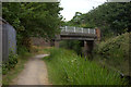
St Mary's Road bridge. Grand Union canal near Langley
Image: © Robert Eva
Taken: 22 Jun 2017
0.10 miles
5
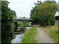
Bridge 9, Slough Arm, Grand Union Canal
St Mary's Road crosses.
Image: © Robin Webster
Taken: 21 Jul 2013
0.11 miles
6
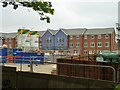
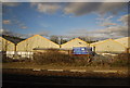
Building site, Langley
A redevelopment of an industrial site, this is part of Waterside Grange - it "features an exclusive selection of new 1 & 2 bedroom apartments and 3 & 4 bedroom houses".
Image: © Robin Webster
Taken: 21 Jul 2013
0.11 miles
7
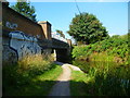
Orange Way after Wiltshire (476)
This is a look back across the canal by the St Mary's Road bridge.
Image: © Shazz
Taken: 4 Sep 2013
0.12 miles
8
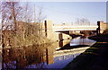
Bridge over the Grand Union Canal
This modern bridge takes St. Mary's Road over the canal.
Image: © Stephen Williams
Taken: 13 Jan 1991
0.12 miles
9
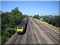
Langley: Main line railway
A westbound First Great Western express approaches the distant twin-arched structure of St Mary's Road bridge. This view was taken from the footbridge to the north of Alderbury Road, west of Langley railway station.
Image: © Nigel Cox
Taken: 18 Jul 2006
0.13 miles
10
Orange Way after Wiltshire (475)
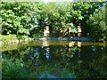
The Orange Way has entered its fifth and final myriad. This wide bit of the canal must be some sort of layby for boats.
Image: © Shazz
Taken: 4 Sep 2013
0.14 miles