IMAGES TAKEN NEAR TO
Chestnut Avenue, SLOUGH, SL3 7DE
Introduction
This page details the photographs taken nearby to Chestnut Avenue, SL3 7DE by members of the Geograph project.
The Geograph project started in 2005 with the aim of publishing, organising and preserving representative images for every square kilometre of Great Britain, Ireland and the Isle of Man.

There are currently over 7.5m images from over14,400 individuals and you can help contribute to the project by visiting https://www.geograph.org.uk
Image Map
Images are licensed for reuse under creativecommons.org/licenses/by-sa/2.0
Notes
- Clicking on the map will re-center to the selected point.
- The higher the marker number, the further away the image location is from the centre of the postcode.
Image Listing (23 Images Found)
Images are licensed for reuse under creativecommons.org/licenses/by-sa/2.0
Image
Details
Distance
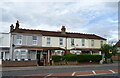
2

George V postbox on Langley Road, Slough
Postbox No. SL3 53.
Image: © JThomas
Taken: 23 May 2022
0.10 miles
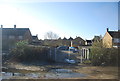
4
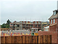
Building site, Langley
A redevelopment of an industrial site, this is part of Waterside Grange - it "features an exclusive selection of new 1 & 2 bedroom apartments and 3 & 4 bedroom houses".
Image: © Robin Webster
Taken: 21 Jul 2013
0.18 miles

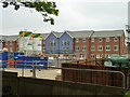
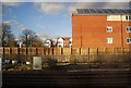
7
Building site, Slough
Part of the 'Waterside Grange' residential redevelopment of an industrial site.
Image: © Robin Webster
Taken: 21 Jul 2013
0.21 miles
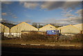
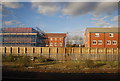
10
Housing estate north of railway line
Looking towards Edgeworth Close
Image: © Clint Mann
Taken: 28 Oct 2015
0.22 miles