IMAGES TAKEN NEAR TO
Lynwood Avenue, SLOUGH, SL3 7BH
Introduction
This page details the photographs taken nearby to Lynwood Avenue, SL3 7BH by members of the Geograph project.
The Geograph project started in 2005 with the aim of publishing, organising and preserving representative images for every square kilometre of Great Britain, Ireland and the Isle of Man.

There are currently over 7.5m images from over14,400 individuals and you can help contribute to the project by visiting https://www.geograph.org.uk
Image Map
Images are licensed for reuse under creativecommons.org/licenses/by-sa/2.0
Notes
- Clicking on the map will re-center to the selected point.
- The higher the marker number, the further away the image location is from the centre of the postcode.
Image Listing (16 Images Found)
Images are licensed for reuse under creativecommons.org/licenses/by-sa/2.0
Image
Details
Distance
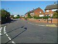
1
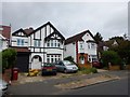
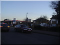
Slough - Lynwood Avenue
Large detached houses.
Image: © James Emmans
Taken: 24 Jun 2017
0.07 miles
2
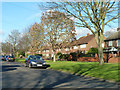
Blandford Road South
A dead end road, although once a through road with Blandford Road North.
Image: © Robin Webster
Taken: 19 Jan 2014
0.08 miles
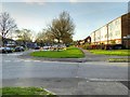
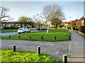
5
London Road, Slough
The standard mixture of 3 bedroom semi ribbon development along the A4 punctuated with petrol stations, albeit many fewer in the 21st century.
Image: © David Howard
Taken: 19 Feb 2012
0.13 miles
7
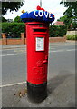
Yarn bombed George V postbox on Langley Road, Slough
Postbox No. SL3 126.
Image: © JThomas
Taken: 23 May 2022
0.19 miles
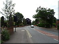
8
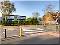
Pedestrian Crossing on Trelawney Avenue
Image: © David Dixon
Taken: 11 Apr 2015
0.20 miles
10

George V postbox on Langley Road, Slough
Postbox No. SL3 53.
Image: © JThomas
Taken: 23 May 2022
0.21 miles