IMAGES TAKEN NEAR TO
Vicarage Way, SLOUGH, SL3 0RD
Introduction
This page details the photographs taken nearby to Vicarage Way, SL3 0RD by members of the Geograph project.
The Geograph project started in 2005 with the aim of publishing, organising and preserving representative images for every square kilometre of Great Britain, Ireland and the Isle of Man.

There are currently over 7.5m images from over14,400 individuals and you can help contribute to the project by visiting https://www.geograph.org.uk
Image Map
Images are licensed for reuse under creativecommons.org/licenses/by-sa/2.0
Notes
- Clicking on the map will re-center to the selected point.
- The higher the marker number, the further away the image location is from the centre of the postcode.
Image Listing (101 Images Found)
Images are licensed for reuse under creativecommons.org/licenses/by-sa/2.0
Image
Details
Distance
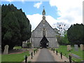
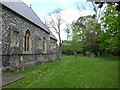
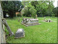
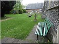
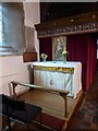
1
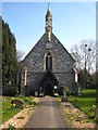
The Church of St Thomas, Colnbrook
Dating from 1849-52 and Grade II Listed.
Image: © Rod Allday
Taken: 24 Mar 2012
0.07 miles
2
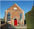
Colnbrook Baptist Chapel
Built in 1871. Detailed history on http://colnbrookbaptistchapel.co.uk/history/
Image: © Des Blenkinsopp
Taken: 6 Nov 2017
0.07 miles