IMAGES TAKEN NEAR TO
Raymond Close, SLOUGH, SL3 0PR
Introduction
This page details the photographs taken nearby to Raymond Close, SL3 0PR by members of the Geograph project.
The Geograph project started in 2005 with the aim of publishing, organising and preserving representative images for every square kilometre of Great Britain, Ireland and the Isle of Man.

There are currently over 7.5m images from over14,400 individuals and you can help contribute to the project by visiting https://www.geograph.org.uk
Image Map
Images are licensed for reuse under creativecommons.org/licenses/by-sa/2.0
Notes
- Clicking on the map will re-center to the selected point.
- The higher the marker number, the further away the image location is from the centre of the postcode.
Image Listing (43 Images Found)
Images are licensed for reuse under creativecommons.org/licenses/by-sa/2.0
Image
Details
Distance
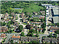
3
Poyle from the air
On approach to Heathrow from the west.
See also Image
Image: © Thomas Nugent
Taken: 19 May 2014
0.12 miles
4
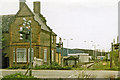
Site of Colnbrook station, 1986
View northward across the B3378 (original Bath Road), towards West Drayton: ex-GWR West Drayton - Staines branch. The station was closed when the passenger service on the branch ceased from 29/3/65. Goods traffic ceased from 3/1/66, but as the photograph shows the line remains open to this point from West Drayton, for traffic to a fuel depot for Heathrow Airport and to an aggregates depot.
Image: © Ben Brooksbank
Taken: 18 May 1986
0.12 miles
5
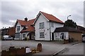
New Bettolo Italian Restaurant, Bath Road, Colnbrook
Image: © Ian S
Taken: 15 Mar 2020
0.12 miles
6
Poyle from the air
On approach to Heathrow from the west.
See also Image
Image: © Thomas Nugent
Taken: 19 May 2014
0.13 miles
7

Pump on the old Bath Road at Poyle
A plaque on the pump reads 'THIS PUMP WAS ERECTED BY ORDER OF 'BEAU' NASH OF BATH IN 1754'
Image: © Rod Allday
Taken: 24 Mar 2012
0.13 miles
8
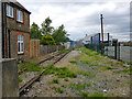
End of line, Colnbrook
The former GWR line from West Drayton to Staines now ends here, at the former level crossing over Bath Road. The old station house on the left.
Image: © Robin Webster
Taken: 10 Jun 2017
0.13 miles
9
The Arora Park Hotel at Poyle
The Bath Road was lined with coaching inns in the days of horse-drawn carriages. Nowadays there are hotels catering for airport customers.
Image: © Rod Allday
Taken: 24 Mar 2012
0.13 miles
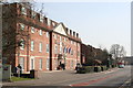
10
Holiday Inn London Heathrow T5 hotel
Bath Road, Colnbrook.
Image: © Ian S
Taken: 15 Mar 2020
0.13 miles