IMAGES TAKEN NEAR TO
Old Bath Road, SLOUGH, SL3 0NJ
Introduction
This page details the photographs taken nearby to Old Bath Road, SL3 0NJ by members of the Geograph project.
The Geograph project started in 2005 with the aim of publishing, organising and preserving representative images for every square kilometre of Great Britain, Ireland and the Isle of Man.

There are currently over 7.5m images from over14,400 individuals and you can help contribute to the project by visiting https://www.geograph.org.uk
Image Map
Images are licensed for reuse under creativecommons.org/licenses/by-sa/2.0
Notes
- Clicking on the map will re-center to the selected point.
- The higher the marker number, the further away the image location is from the centre of the postcode.
Image Listing (27 Images Found)
Images are licensed for reuse under creativecommons.org/licenses/by-sa/2.0
Image
Details
Distance
1
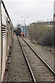
Aviation fuel tank wagons on Colnbrook Branch
View of a rake of wagons bringing aviation fuel to Heathrow Airport, seen from a visiting charter train
Image: © Roger Templeman
Taken: 28 Jan 2012
0.05 miles
2
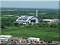
Colnbrook incinerator from the air
On approach to Heathrow from the west.
See also Image
Image: © Thomas Nugent
Taken: 19 May 2014
0.13 miles
3
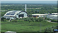
Colnbrook incinerator from the air
On approach to Heathrow from the west.
See also Image
Image: © Thomas Nugent
Taken: 19 May 2014
0.16 miles
4
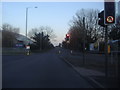
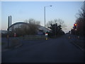
The Colnbrook Bypass by the Grundon waste incinerator
Image: © David Howard
Taken: 19 Feb 2012
0.16 miles
5
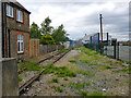
Site of Colnbrook station, 1986
View northward across the B3378 (original Bath Road), towards West Drayton: ex-GWR West Drayton - Staines branch. The station was closed when the passenger service on the branch ceased from 29/3/65. Goods traffic ceased from 3/1/66, but as the photograph shows the line remains open to this point from West Drayton, for traffic to a fuel depot for Heathrow Airport and to an aggregates depot.
Image: © Ben Brooksbank
Taken: 18 May 1986
0.16 miles
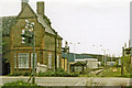
7
End of line, Colnbrook
The former GWR line from West Drayton to Staines now ends here, at the former level crossing over Bath Road. The old station house on the left.
Image: © Robin Webster
Taken: 10 Jun 2017
0.18 miles
10
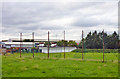
Disused golf driving range, Poyle
This drove towards the M25, which is only a bit over 200 m away.
Image: © Robin Webster
Taken: 10 Jun 2017
0.19 miles