IMAGES TAKEN NEAR TO
Horton Road, SLOUGH, SL3 0LW
Introduction
This page details the photographs taken nearby to Horton Road, SL3 0LW by members of the Geograph project.
The Geograph project started in 2005 with the aim of publishing, organising and preserving representative images for every square kilometre of Great Britain, Ireland and the Isle of Man.

There are currently over 7.5m images from over14,400 individuals and you can help contribute to the project by visiting https://www.geograph.org.uk
Image Map
Images are licensed for reuse under creativecommons.org/licenses/by-sa/2.0
Notes
- Clicking on the map will re-center to the selected point.
- The higher the marker number, the further away the image location is from the centre of the postcode.
Image Listing (36 Images Found)
Images are licensed for reuse under creativecommons.org/licenses/by-sa/2.0
Image
Details
Distance
7
Upside down Union Flag #36
At an house on the High Street, Colnbrook.
Image: © Ian S
Taken: 4 Jun 2012
0.15 miles

10
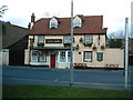
Red Lion, Colnbrook
Details of this and other pubs in Colnbrook at http://www.beerintheevening.com/pubs/s/16/16538/Red_Lion/Colnbrook
Image: © Ray Stanton
Taken: 2 Mar 2006
0.15 miles