IMAGES TAKEN NEAR TO
Mill Street, SLOUGH, SL3 0JR
Introduction
This page details the photographs taken nearby to Mill Street, SL3 0JR by members of the Geograph project.
The Geograph project started in 2005 with the aim of publishing, organising and preserving representative images for every square kilometre of Great Britain, Ireland and the Isle of Man.

There are currently over 7.5m images from over14,400 individuals and you can help contribute to the project by visiting https://www.geograph.org.uk
Image Map
Images are licensed for reuse under creativecommons.org/licenses/by-sa/2.0
Notes
- Clicking on the map will re-center to the selected point.
- The higher the marker number, the further away the image location is from the centre of the postcode.
Image Listing (103 Images Found)
Images are licensed for reuse under creativecommons.org/licenses/by-sa/2.0
Image
Details
Distance
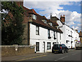
1
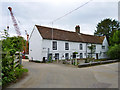
Mill House and Tanhouse Farmhouse, Colnbrook
A grade II listed building, the left part early 18th century, the right 17th century.
Image: © Robin Webster
Taken: 10 Jun 2017
0.03 miles
2
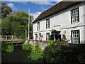
The Mill House and mill stream, Mill Street
I think that the stream is an artificial channel diverted from the Colne Brook to the northeast, just south of where the Colnbrook By-pass now crosses over it.
Image: © Mike Quinn
Taken: 8 Aug 2018
0.03 miles
3
The Mill House and mill stream, Mill Street (2)
See also Image
Image: © Mike Quinn
Taken: 8 Aug 2018
0.04 miles
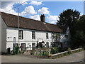
4

Mill stream and bridge, Colnbrook Mill
The mill house is on the right. The actual mill seems to have been just above (beyond) the bridge, but no real trace remains.
Image: © Robin Webster
Taken: 10 Jun 2017
0.04 miles
5
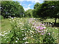
Wild flowers at Albany Park
This small park is on the edge of Colnbrook. The mowing has left this area of wild flowers which are mostly ox-eye daisy and mallow. Cox's Orchard has been planted on part of Albany Park - see http://www.geograph.org.uk/photo/5815130
Image: © Marathon
Taken: 20 Jun 2018
0.05 miles
6
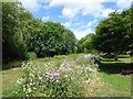
Wild flowers at Albany Park
This small park is on the edge of Colnbrook. The mowing has left this area of wild flowers which are mostly ox-eye daisy and mallow. Cox's Orchard has been planted on part of Albany Park - see http://www.geograph.org.uk/photo/5815130
Image: © Marathon
Taken: 20 Jun 2018
0.06 miles
7
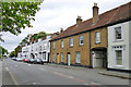
Fairmead and The Haven, Colnbrook
Early 19th century, along with most of its neighbours, a grade II listed building.
Image: © Robin Webster
Taken: 10 Jun 2017
0.08 miles
8
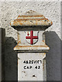
Coal tax boundary post no.77, Park Street, Colnbrook (detail)
Image: © Mike Quinn
Taken: 8 Aug 2018
0.08 miles
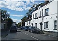
9
Park Street, Colnbrook (3)
Image: © Mike Quinn
Taken: 8 Aug 2018
0.08 miles