IMAGES TAKEN NEAR TO
High Street, SLOUGH, SL3 0HA
Introduction
This page details the photographs taken nearby to High Street, SL3 0HA by members of the Geograph project.
The Geograph project started in 2005 with the aim of publishing, organising and preserving representative images for every square kilometre of Great Britain, Ireland and the Isle of Man.

There are currently over 7.5m images from over14,400 individuals and you can help contribute to the project by visiting https://www.geograph.org.uk
Image Map
Images are licensed for reuse under creativecommons.org/licenses/by-sa/2.0
Notes
- Clicking on the map will re-center to the selected point.
- The higher the marker number, the further away the image location is from the centre of the postcode.
Image Listing (101 Images Found)
Images are licensed for reuse under creativecommons.org/licenses/by-sa/2.0
Image
Details
Distance
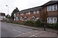
2
Colnbrook High Street
Traditional old buildings which are actually the age they look rather than more recent reproductions.
Image: © David Howard
Taken: 2 Nov 2014
0.02 miles
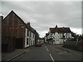
3
Colnbrook and Poyle United Church
Situated in High Street SL3 0JZ, this modern Church is one of twelve Churches in the Thames Valley Methodist Circuit. Services are held here at 10.30am every Sunday whilst Holy Communion is included in the Service held on the third Sunday of each month. A Christian Fellowship meeting takes place here on the First Tuesday of each month at 2.30pm. Both Methodist and URC (United Reformed Church) meet in this Church.
Image: © David Hillas
Taken: 31 May 2014
0.02 miles


8
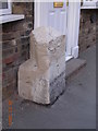
Old Milestone by High Street, Colnbrook
Carved stone post by the UC road, in parish of Colnbrook with Poyle (Windsor and Maidenhead District), High Street; by No. 3, Milestone Cottages, opposite the Ostrich PH, against house wall on footpath, on North side of road. Bath Road limestone diamond, erected by the Colnbrook, Datchet & Slough turnpike trust in the 18th century.
Inscription reads:-
H(ounslow)
7
MAIDENHEAD
9
( ? )
Carved benchmark bottom front face.
Grade II listed.
List Entry Number: 1124407 https://historicengland.org.uk/listing/the-list/list-entry/1124407
Milestone Society National ID: BU_LB17
Image: © A Rosevear & J Higgins
Taken: 10 Oct 2001
0.04 miles

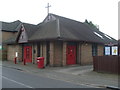
10
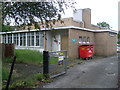
Colnbrook Telephone Exchange
Situated in High Street, this TE would seem to date from the 1960s and serves Colnbrook plus Horton, Longford, Poyle and Stanwell Moor nearby. A "Thieves Beware" notice can be seen on the gate whilst a red rubbish bin is at the side of the TE. The numbering range of this TE is (01753) 68xxxx, the (01753) referring to the Slough group of TEs and its postcode is SL3 0JZ.
Image: © David Hillas
Taken: 31 May 2014
0.06 miles