IMAGES TAKEN NEAR TO
Lismore Park, SLOUGH, SL2 5UD
Introduction
This page details the photographs taken nearby to Lismore Park, SL2 5UD by members of the Geograph project.
The Geograph project started in 2005 with the aim of publishing, organising and preserving representative images for every square kilometre of Great Britain, Ireland and the Isle of Man.

There are currently over 7.5m images from over14,400 individuals and you can help contribute to the project by visiting https://www.geograph.org.uk
Image Map
Images are licensed for reuse under creativecommons.org/licenses/by-sa/2.0
Notes
- Clicking on the map will re-center to the selected point.
- The higher the marker number, the further away the image location is from the centre of the postcode.
Image Listing (14 Images Found)
Images are licensed for reuse under creativecommons.org/licenses/by-sa/2.0
Image
Details
Distance
3
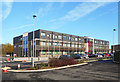
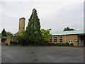
Lynch Hill Enterprise Academy
A new school opened in September 2014.
Image: © Des Blenkinsopp
Taken: 2 Nov 2018
0.08 miles
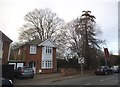
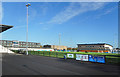
5
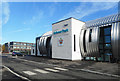
Arbour Park Sports Centre
A new stadium along Stoke Road.
Image: © Des Blenkinsopp
Taken: 2 Nov 2018
0.12 miles
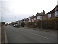
6
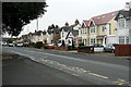
Stoke Road
This is the road from Stoke Poges, the B416 in the northern part of Slough. This shows a selection of Edwardian houses, many of which had had individual makeovers.
Image: © Graham Horn
Taken: 23 Feb 2012
0.14 miles
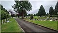
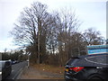
8
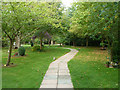
Path, Slough Crematorium
The main building is just through the shrubbery to the right.
Image: © Robin Webster
Taken: 13 Sep 2014
0.19 miles