IMAGES TAKEN NEAR TO
The Normans, SLOUGH, SL2 5TT
Introduction
This page details the photographs taken nearby to The Normans, SL2 5TT by members of the Geograph project.
The Geograph project started in 2005 with the aim of publishing, organising and preserving representative images for every square kilometre of Great Britain, Ireland and the Isle of Man.

There are currently over 7.5m images from over14,400 individuals and you can help contribute to the project by visiting https://www.geograph.org.uk
Image Map
Images are licensed for reuse under creativecommons.org/licenses/by-sa/2.0
Notes
- Clicking on the map will re-center to the selected point.
- The higher the marker number, the further away the image location is from the centre of the postcode.
Image Listing (15 Images Found)
Images are licensed for reuse under creativecommons.org/licenses/by-sa/2.0
Image
Details
Distance
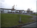
1
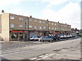
Shops in Knolton Way, Slough
The shops are in Knolton Way, photo looking west from the end of Moat Drive.
Image: © David Hawgood
Taken: 21 Feb 2006
0.16 miles
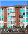
2
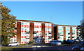
Red and Blue Panels
A bit of colour on these blocks along Wexham Road.
Image: © Des Blenkinsopp
Taken: 2 Nov 2018
0.18 miles
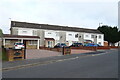
6
Bikes & Balconies
Detail of one of the buildings shown in Image
Image: © Des Blenkinsopp
Taken: 2 Nov 2018
0.19 miles

9
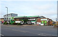
Service station on Wexham Road, Slough
Petrol 170.9p.
Diesel 181.9p.
Image: © JThomas
Taken: 26 May 2022
0.20 miles
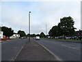
10
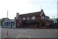
The King Wexham, Slough
On Wexham Road.
See Image] for sign.
Image: © JThomas
Taken: 26 May 2022
0.21 miles