IMAGES TAKEN NEAR TO
Beresford Avenue, SLOUGH, SL2 5LE
Introduction
This page details the photographs taken nearby to Beresford Avenue, SL2 5LE by members of the Geograph project.
The Geograph project started in 2005 with the aim of publishing, organising and preserving representative images for every square kilometre of Great Britain, Ireland and the Isle of Man.

There are currently over 7.5m images from over14,400 individuals and you can help contribute to the project by visiting https://www.geograph.org.uk
Image Map
Images are licensed for reuse under creativecommons.org/licenses/by-sa/2.0
Notes
- Clicking on the map will re-center to the selected point.
- The higher the marker number, the further away the image location is from the centre of the postcode.
Image Listing (20 Images Found)
Images are licensed for reuse under creativecommons.org/licenses/by-sa/2.0
Image
Details
Distance
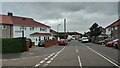
5
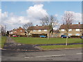
The Frithe, Upton Lea, Slough
Looking west across the end of Knolton way
Image: © David Hawgood
Taken: 21 Feb 2006
0.15 miles

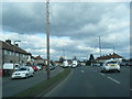
7
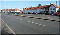
Across Uxbridge Road
These houses line the dual carriageway Uxbridge Road opposite Broadmark Road traffic lights. It is difficult to stop along this road to take a photo, but there was a convenient lay by here just after the lights.
Image: © Graham Horn
Taken: 23 Feb 2012
0.17 miles
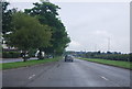
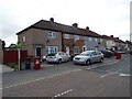
9
Rochfords Gardens
1970s houses in Slough.
Image: © Burgess Von Thunen
Taken: 9 Nov 2011
0.17 miles
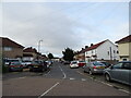
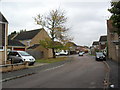
10
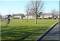
Green in Upton Lea
This is at the junction of The Frythe, left, and Upton Way, across the picture. Upton Lea is a large housing estate to the north of Slough.
Image: © Graham Horn
Taken: 23 Feb 2012
0.21 miles