IMAGES TAKEN NEAR TO
Adrians Walk, SLOUGH, SL2 5EU
Introduction
This page details the photographs taken nearby to Adrians Walk, SL2 5EU by members of the Geograph project.
The Geograph project started in 2005 with the aim of publishing, organising and preserving representative images for every square kilometre of Great Britain, Ireland and the Isle of Man.

There are currently over 7.5m images from over14,400 individuals and you can help contribute to the project by visiting https://www.geograph.org.uk
Image Map
Images are licensed for reuse under creativecommons.org/licenses/by-sa/2.0
Notes
- Clicking on the map will re-center to the selected point.
- The higher the marker number, the further away the image location is from the centre of the postcode.
Image Listing (129 Images Found)
Images are licensed for reuse under creativecommons.org/licenses/by-sa/2.0
Image
Details
Distance
1
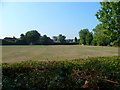
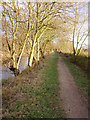
Orange Way after Wiltshire (466)
This view from the towpath is across Bower Playing Fields.
Image: © Shazz
Taken: 4 Sep 2013
0.09 miles
2
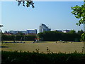
Orange Way after Wiltshire (467)
Here's a look to the play area in Bower Playing Fields.
Image: © Shazz
Taken: 4 Sep 2013
0.12 miles
3
Theory Test Centre, Slough
This photo shows the driving theory test centre at Brooklands House, Petersfield Avenue, SL2 5DY. Candidates have to pass their driving theory test here or elsewhere, before they can take their practical driving tests.
Image: © David Hillas
Taken: 31 Aug 2018
0.13 miles
6

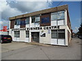
Former Slough Driving Test Centre
Situated in Grays Place SL2 5AF, this driving test centre replaced the one at 64 Stoke Road some years ago, the latter having since been demolished. This DTC carries out practical driving tests for cars and taxis. The parking area is behind the DTC, the entrance being to the left of the photo. Update: this driving test centre closed on Tuesday 3rd January 2017 and practical driving tests moved to the new centre at Langley Pavilion, Langley Road SL3 8BS from the following day. More recently, it has again moved to 12 Waterside Drive, Langley, SL3 6EZ.
Update: this former driving test centre has since been demolished with building work currently taking place on this site.
Image: © David Hillas
Taken: 6 Apr 2016
0.14 miles
7
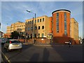
Beacon House, Slough
With its distinctive circular red brick tower feature, this office building is at the corner of Stoke Road (left) and Mill Street.
Image: © Derek Harper
Taken: 20 Sep 2010
0.14 miles
8
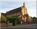
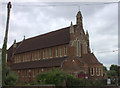
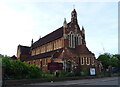
St. Paul's Church, Slough
The Victorian church, which looks as if it dates from the last years of the C19, is on Stoke Road (the B416).
Image: © Derek Harper
Taken: 20 Sep 2010
0.15 miles
9

Theory Test Centre Notice, Slough
This notice is located on the right of the entrance to the driving theory test centre at Brooklands House, Petersfield Avenue, SL2 5DY.
Image: © David Hillas
Taken: 31 Aug 2018
0.15 miles
10
Grand Union Canal: Slough branch
Unlikely scene in the middle of Slough. Taken on a winter evening, looking east.
Image: © Sheila Russell
Taken: 26 Jan 2006
0.15 miles