IMAGES TAKEN NEAR TO
Fleetwood Road, SLOUGH, SL2 5EQ
Introduction
This page details the photographs taken nearby to Fleetwood Road, SL2 5EQ by members of the Geograph project.
The Geograph project started in 2005 with the aim of publishing, organising and preserving representative images for every square kilometre of Great Britain, Ireland and the Isle of Man.

There are currently over 7.5m images from over14,400 individuals and you can help contribute to the project by visiting https://www.geograph.org.uk
Image Map
Images are licensed for reuse under creativecommons.org/licenses/by-sa/2.0
Notes
- Clicking on the map will re-center to the selected point.
- The higher the marker number, the further away the image location is from the centre of the postcode.
Image Listing (124 Images Found)
Images are licensed for reuse under creativecommons.org/licenses/by-sa/2.0
Image
Details
Distance
1
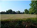
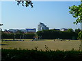
Orange Way after Wiltshire (466)
This view from the towpath is across Bower Playing Fields.
Image: © Shazz
Taken: 4 Sep 2013
0.08 miles
4
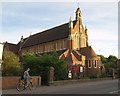
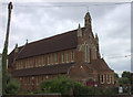
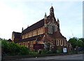
St. Paul's Church, Slough
The Victorian church, which looks as if it dates from the last years of the C19, is on Stoke Road (the B416).
Image: © Derek Harper
Taken: 20 Sep 2010
0.10 miles
5
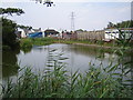
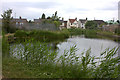
Grand Union Canal (Slough Arm)
The uninspiring end of the 1882-built Slough Arm of the Grand Union Canal to the east of Stoke Road in Slough, with the boat turning head basin in the foreground. The canal was built originally to convey bricks, and then gravel, to London. Later the canal was used to fill the brick and gravel pits with London's waste.
Image: © Nigel Cox
Taken: 26 Jul 2006
0.11 miles
6
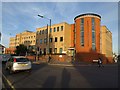
Beacon House, Slough
With its distinctive circular red brick tower feature, this office building is at the corner of Stoke Road (left) and Mill Street.
Image: © Derek Harper
Taken: 20 Sep 2010
0.12 miles
7
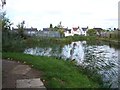
Canal Basin
Western end of the Slough Arm, Grand Union Canal.
Image: © Rob Emms
Taken: 19 Sep 2017
0.13 miles
8
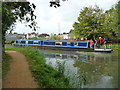
Boat winding at end of Slough Arm
A little before the extreme end is a winding hole. The boat had no prominently displayed name.
Image: © Robin Webster
Taken: 13 Sep 2014
0.14 miles
9
Orange Way after Wiltshire (467)
Here's a look to the play area in Bower Playing Fields.
Image: © Shazz
Taken: 4 Sep 2013
0.14 miles
10
Slough canal basin
The end of the Slough Arm from the Grand Union canal
Image: © Robert Eva
Taken: 22 Jun 2017
0.14 miles