IMAGES TAKEN NEAR TO
Crown Lane, SLOUGH, SL2 3SF
Introduction
This page details the photographs taken nearby to Crown Lane, SL2 3SF by members of the Geograph project.
The Geograph project started in 2005 with the aim of publishing, organising and preserving representative images for every square kilometre of Great Britain, Ireland and the Isle of Man.

There are currently over 7.5m images from over14,400 individuals and you can help contribute to the project by visiting https://www.geograph.org.uk
Image Map (Loading...)


Getting Data...Please wait
Leaflet Map data © OpenStreetMap
Images are licensed for reuse under creativecommons.org/licenses/by-sa/2.0
Notes
- Clicking on the map will re-center to the selected point.
- The higher the marker number, the further away the image location is from the centre of the postcode.
Image Listing (8 Images Found)
Images are licensed for reuse under creativecommons.org/licenses/by-sa/2.0
Image
Details
Distance
1
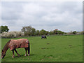
Fields at Farnham Royal
On the western side of Blackpond Lane.
Image: © Andrew Smith
Taken: 30 Apr 2006
0.14 miles
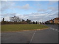
4
Devonshire Green, Farnham Royal
At the junction with Blackpond Lane.
Image: © Andrew Smith
Taken: 30 Apr 2006
0.21 miles
5

Farnham Lane, Farnham Royal
Opposite the rugby pitch
Image: © David Howard
Taken: 8 Mar 2015
0.22 miles
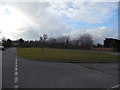
6
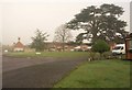
Devonshire Green
A turning off Blackpond Lane (left) with attractive trees on the green ahead. This is very similar to Image, but on a misty day.
Image: © Derek Harper
Taken: 19 Nov 2010
0.24 miles
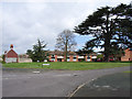
7

East Burnham Park
Now used as a conference centre.
Image: © Kevin White
Taken: 21 Sep 2009
0.25 miles
