IMAGES TAKEN NEAR TO
Parsonage Lane, SLOUGH, SL2 3PA
Introduction
This page details the photographs taken nearby to Parsonage Lane, SL2 3PA by members of the Geograph project.
The Geograph project started in 2005 with the aim of publishing, organising and preserving representative images for every square kilometre of Great Britain, Ireland and the Isle of Man.

There are currently over 7.5m images from over14,400 individuals and you can help contribute to the project by visiting https://www.geograph.org.uk
Image Map
Images are licensed for reuse under creativecommons.org/licenses/by-sa/2.0
Notes
- Clicking on the map will re-center to the selected point.
- The higher the marker number, the further away the image location is from the centre of the postcode.
Image Listing (4 Images Found)
Images are licensed for reuse under creativecommons.org/licenses/by-sa/2.0
Image
Details
Distance
1
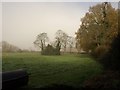
Field beside Purton Lane
From the eastern end of a public footpath linking Purton Lane (behind the hedge on the right) to Beaconsfield Road. The little circle of trees may hide a pond, or may just be ornamental.
Image: © Derek Harper
Taken: 19 Nov 2010
0.17 miles
2
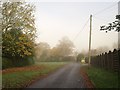
Purton Lane
The road, seen on a very misty day, runs parallel to Beaconsfield Road. Here it leaves houses to run through a scrap of countryside before reaching Farnham Common.
Image: © Derek Harper
Taken: 19 Nov 2010
0.21 miles
4
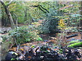
Brockhurst Wood
Brook in Brockhurst Wood
Image: © Shaun Ferguson
Taken: 30 Oct 2012
0.23 miles