IMAGES TAKEN NEAR TO
Blackpond Lane, SLOUGH, SL2 3EP
Introduction
This page details the photographs taken nearby to Blackpond Lane, SL2 3EP by members of the Geograph project.
The Geograph project started in 2005 with the aim of publishing, organising and preserving representative images for every square kilometre of Great Britain, Ireland and the Isle of Man.

There are currently over 7.5m images from over14,400 individuals and you can help contribute to the project by visiting https://www.geograph.org.uk
Image Map
Images are licensed for reuse under creativecommons.org/licenses/by-sa/2.0
Notes
- Clicking on the map will re-center to the selected point.
- The higher the marker number, the further away the image location is from the centre of the postcode.
Image Listing (47 Images Found)
Images are licensed for reuse under creativecommons.org/licenses/by-sa/2.0
Image
Details
Distance
1
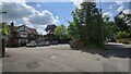
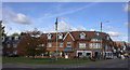
Southmead Surgery
Local healthcare service on Blackpond Lane.
Image: © James Emmans
Taken: 23 Jun 2021
0.02 miles
2
Farnham Common Telephone Exchange, Bucks
Situated on the A355 Beaconsfield Road, this TE replaced the former Manual TE in the 1960s, http://www.geograph.org.uk/photo/2330450 refers. Besides Farnham Common, this TE also serves Farnham Royal, Hedgerley and Stoke Poges nearby. It has (01753) 64xxxx numbers and its postcode is SL2 3ND.
Image: © David Hillas
Taken: 22 Jan 2011
0.09 miles
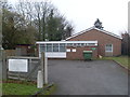
4
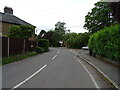
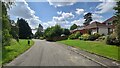
Blackpond Lane
The road runs past detached houses and autumnal bushes; on the left, Hill Place turns off. A misty day.
Image: © Derek Harper
Taken: 19 Nov 2010
0.12 miles
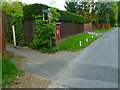
6
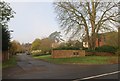
Hill Place
The turning seen on the left of Image, a cul-de-sac of twelve detached houses.
Image: © Derek Harper
Taken: 19 Nov 2010
0.14 miles
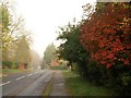
7
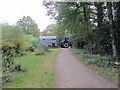
Small offcut section of the old Beaconsfield Road
The A355 was upgraded and straighten in this area.
Image: © James Emmans
Taken: 23 Jun 2021
0.16 miles
8
Horsebox and tractor, Burnham Beeches
The horsebox contains ponies which have been grazing on East Burnham Common.
Image: © David Hawgood
Taken: 6 Sep 2021
0.16 miles
9
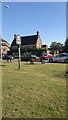
Village Green, Farnham Common
The village green of Farnham Common lies adjacent to the A355 Beaconsfield Road, and is located in the parish of Farnham Royal, the district of South Buckinghamshire, and county of Buckinghamshire, England. The green features a village sign designed by local artist Ron Whiting that was erected in 2000.
Image: © Steven Haslington
Taken: 9 Sep 2012
0.16 miles
10
Junction of Kingsway and Beaconsfield Rd, Farnham Common
Image: © Robert Eva
Taken: 6 Oct 2017
0.16 miles