IMAGES TAKEN NEAR TO
Charlton Close, SLOUGH, SL1 9HD
Introduction
This page details the photographs taken nearby to Charlton Close, SL1 9HD by members of the Geograph project.
The Geograph project started in 2005 with the aim of publishing, organising and preserving representative images for every square kilometre of Great Britain, Ireland and the Isle of Man.

There are currently over 7.5m images from over14,400 individuals and you can help contribute to the project by visiting https://www.geograph.org.uk
Image Map
Images are licensed for reuse under creativecommons.org/licenses/by-sa/2.0
Notes
- Clicking on the map will re-center to the selected point.
- The higher the marker number, the further away the image location is from the centre of the postcode.
Image Listing (8 Images Found)
Images are licensed for reuse under creativecommons.org/licenses/by-sa/2.0
Image
Details
Distance
1
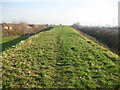
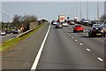
Cippenham: M4 Motorway embankment
This embankment or bund runs for about 800 metres along the north side of the M4 Motorway and appears to have been built to afford sound or sight (or both) protection to the residents of the Cippenham Meadows housing estate (on the left) from the traffic on the motorway (to the right).
Image: © Nigel Cox
Taken: 8 Jan 2009
0.16 miles
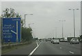
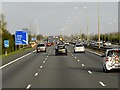
4
M4 west of Junction 6 (westbound)
Traffic merging on the left.
Image: © Julian P Guffogg
Taken: 7 Aug 2013
0.22 miles
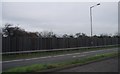
7
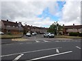
Slough - Entrance to Cress Road
Junction with Keel Drive.
Image: © James Emmans
Taken: 24 Jun 2017
0.23 miles
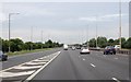
8
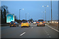
Slough : M4 Motorway
The M4 Motorway between Junction 7 (Huntercombe Spur) and Junction 6 (Tuns Lane).
Image: © Lewis Clarke
Taken: 23 Mar 2018
0.23 miles