IMAGES TAKEN NEAR TO
Dorney Wood Road, SLOUGH, SL1 8PS
Introduction
This page details the photographs taken nearby to Dorney Wood Road, SL1 8PS by members of the Geograph project.
The Geograph project started in 2005 with the aim of publishing, organising and preserving representative images for every square kilometre of Great Britain, Ireland and the Isle of Man.

There are currently over 7.5m images from over14,400 individuals and you can help contribute to the project by visiting https://www.geograph.org.uk
Image Map
Images are licensed for reuse under creativecommons.org/licenses/by-sa/2.0
Notes
- Clicking on the map will re-center to the selected point.
- The higher the marker number, the further away the image location is from the centre of the postcode.
Image Listing (9 Images Found)
Images are licensed for reuse under creativecommons.org/licenses/by-sa/2.0
Image
Details
Distance
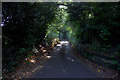
1
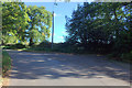
Junction of Longmead Lane and Dorney Wood Road
Image: © Robert Eva
Taken: 6 Oct 2017
0.08 miles
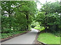
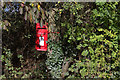
2
Path to Dropmore Road from Dorney Wood Road
Image: © Robert Eva
Taken: 6 Oct 2017
0.10 miles
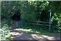
5
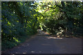
Green Lane, Burnham
Looking south from the Longmead Lane
Image: © Robert Eva
Taken: 6 Oct 2017
0.19 miles
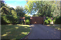
6
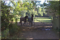
Field gate off Dorney Wood Road
Presumably, the horses belong to Snowball Farm
Image: © Robert Eva
Taken: 6 Oct 2017
0.20 miles
7

South Bucks countryside
Taken from Dorney Wood Road north of Burnham looking south. Country such as this is typical of the gridsquare.
Image: © David Kemp
Taken: 10 Feb 2006
0.23 miles