IMAGES TAKEN NEAR TO
Littleworth Road, SLOUGH, SL1 8PF
Introduction
This page details the photographs taken nearby to Littleworth Road, SL1 8PF by members of the Geograph project.
The Geograph project started in 2005 with the aim of publishing, organising and preserving representative images for every square kilometre of Great Britain, Ireland and the Isle of Man.

There are currently over 7.5m images from over14,400 individuals and you can help contribute to the project by visiting https://www.geograph.org.uk
Image Map
Images are licensed for reuse under creativecommons.org/licenses/by-sa/2.0
Notes
- Clicking on the map will re-center to the selected point.
- The higher the marker number, the further away the image location is from the centre of the postcode.
Image Listing (62 Images Found)
Images are licensed for reuse under creativecommons.org/licenses/by-sa/2.0
Image
Details
Distance
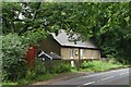
5
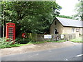
Dropmore Village Hall and rareish red phone box
Image: © Kevin White
Taken: 14 Aug 2008
0.02 miles
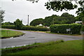
7
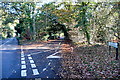
Beeches Way (23)
The path on the left of Dorney Road is taken to go across Littleworth Common.
Image: © Shazz
Taken: 13 May 2013
0.03 miles
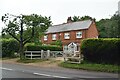
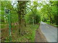
9
Boveney Wood Lane
The start of a promising autumn walk.
Image: © Graham Horn
Taken: 13 Nov 2011
0.03 miles