IMAGES TAKEN NEAR TO
Taplow Common Road, SLOUGH, SL1 8NR
Introduction
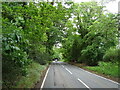
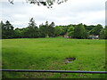
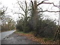
This page details the photographs taken nearby to Taplow Common Road, SL1 8NR by members of the Geograph project.
The Geograph project started in 2005 with the aim of publishing, organising and preserving representative images for every square kilometre of Great Britain, Ireland and the Isle of Man.

There are currently over 7.5m images from over14,400 individuals and you can help contribute to the project by visiting https://www.geograph.org.uk
Image Map
Images are licensed for reuse under creativecommons.org/licenses/by-sa/2.0
Notes
- Clicking on the map will re-center to the selected point.
- The higher the marker number, the further away the image location is from the centre of the postcode.
Image Listing (6 Images Found)
Images are licensed for reuse under creativecommons.org/licenses/by-sa/2.0
Image
Details
Distance
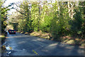
1
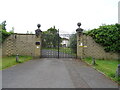
Gateway to Burwood House
Off Taplow Common Road.
Image: © JThomas
Taken: 26 May 2022
0.05 miles
6
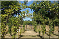
Orchard at Cliveden
A new orchard has been created by the National Trust at Cliveden. Round in shape, with the fruit trees trained into archways as seen here by the entrance.
Image: © Des Blenkinsopp
Taken: 8 Aug 2022
0.25 miles