IMAGES TAKEN NEAR TO
Hazelhurst Road, SLOUGH, SL1 8ED
Introduction
This page details the photographs taken nearby to Hazelhurst Road, SL1 8ED by members of the Geograph project.
The Geograph project started in 2005 with the aim of publishing, organising and preserving representative images for every square kilometre of Great Britain, Ireland and the Isle of Man.

There are currently over 7.5m images from over14,400 individuals and you can help contribute to the project by visiting https://www.geograph.org.uk
Image Map
Images are licensed for reuse under creativecommons.org/licenses/by-sa/2.0
Notes
- Clicking on the map will re-center to the selected point.
- The higher the marker number, the further away the image location is from the centre of the postcode.
Image Listing (10 Images Found)
Images are licensed for reuse under creativecommons.org/licenses/by-sa/2.0
Image
Details
Distance
1
Green on Green Lane, Burnham
The daffodils and crocuses are out.
Image: © David Howard
Taken: 17 Feb 2022
0.02 miles
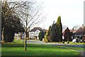
2
Neat or What
Love those shrubs.
This is The Fairway, Burnham.
Hurrah for the suburbs.
Image: © Des Blenkinsopp
Taken: 15 Nov 2013
0.09 miles
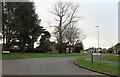
4
The Fairway, Burnham (Bucks)
Taken at the junction with Green Lane looking west along The Fairway.
Image: © David Kemp
Taken: 10 Feb 2006
0.12 miles
6
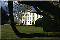
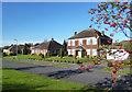
Burnham Beeches Hotel
This house was originally built in 1727 as a family residence, but is now a hotel.
Image: © Stephen McKay
Taken: 2 Mar 2006
0.13 miles
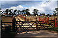
7
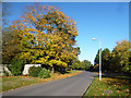
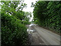
Green Lane, Burnham
Going a bit yellow this time of year, but you get the idea.
Image: © Des Blenkinsopp
Taken: 15 Nov 2013
0.16 miles