IMAGES TAKEN NEAR TO
Britwell Road, SLOUGH, SL1 8AG
Introduction
This page details the photographs taken nearby to Britwell Road, SL1 8AG by members of the Geograph project.
The Geograph project started in 2005 with the aim of publishing, organising and preserving representative images for every square kilometre of Great Britain, Ireland and the Isle of Man.

There are currently over 7.5m images from over14,400 individuals and you can help contribute to the project by visiting https://www.geograph.org.uk
Image Map
Images are licensed for reuse under creativecommons.org/licenses/by-sa/2.0
Notes
- Clicking on the map will re-center to the selected point.
- The higher the marker number, the further away the image location is from the centre of the postcode.
Image Listing (37 Images Found)
Images are licensed for reuse under creativecommons.org/licenses/by-sa/2.0
Image
Details
Distance
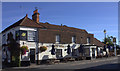
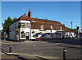
3
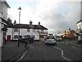
Britwell Road at the junction of High Street Burnham
Image: © David Howard
Taken: 8 Mar 2015
0.08 miles
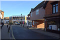
8
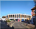
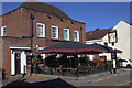
Tesco Schmessco
Burnham High Street is mostly a pleasant mixture of old buildings of various ages.
There may well be those who consider this one is an unsympathetic addition.
Image: © Des Blenkinsopp
Taken: 15 Nov 2013
0.09 miles
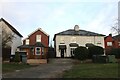
9
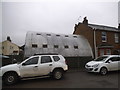
AMS Burnham on Dropmore Road, Burnham
It is a chemical company
Image: © David Howard
Taken: 27 Jan 2018
0.11 miles