IMAGES TAKEN NEAR TO
The Pound, SLOUGH, SL1 7HE
Introduction
This page details the photographs taken nearby to The Pound, SL1 7HE by members of the Geograph project.
The Geograph project started in 2005 with the aim of publishing, organising and preserving representative images for every square kilometre of Great Britain, Ireland and the Isle of Man.

There are currently over 7.5m images from over14,400 individuals and you can help contribute to the project by visiting https://www.geograph.org.uk
Image Map
Images are licensed for reuse under creativecommons.org/licenses/by-sa/2.0
Notes
- Clicking on the map will re-center to the selected point.
- The higher the marker number, the further away the image location is from the centre of the postcode.
Image Listing (23 Images Found)
Images are licensed for reuse under creativecommons.org/licenses/by-sa/2.0
Image
Details
Distance
2
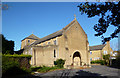
Our Lady of Peace Church
The foundation stone was laid in 1957 and the church opened in 1958.
Image: © Des Blenkinsopp
Taken: 15 Nov 2013
0.18 miles
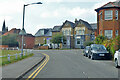
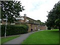
4
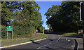
Windsor Lane, Burnham
At the Priory Road end looking north.
Image: © Robert Eva
Taken: 6 Oct 2017
0.18 miles
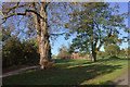
5
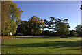
Burnham Park. Exercise equipment and back of the library
Image: © Robert Eva
Taken: 6 Oct 2017
0.19 miles
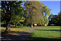
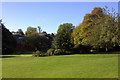
7
Burnham Park looking west towards the playground
Image: © Robert Eva
Taken: 6 Oct 2017
0.21 miles
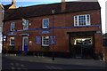
10
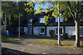
Burnham Park Hall,Burnham,Bucks boarded for demolition
Image: © Kevin White
Taken: 17 Jun 2009
0.22 miles