IMAGES TAKEN NEAR TO
Hitcham Road, SLOUGH, SL1 7DX
Introduction
This page details the photographs taken nearby to Hitcham Road, SL1 7DX by members of the Geograph project.
The Geograph project started in 2005 with the aim of publishing, organising and preserving representative images for every square kilometre of Great Britain, Ireland and the Isle of Man.

There are currently over 7.5m images from over14,400 individuals and you can help contribute to the project by visiting https://www.geograph.org.uk
Image Map
Images are licensed for reuse under creativecommons.org/licenses/by-sa/2.0
Notes
- Clicking on the map will re-center to the selected point.
- The higher the marker number, the further away the image location is from the centre of the postcode.
Image Listing (9 Images Found)
Images are licensed for reuse under creativecommons.org/licenses/by-sa/2.0
Image
Details
Distance
3
Hitcham Road
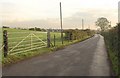
The road leads south from Hitcham towards the Marshgate Trading Estate passes a gate and some intermittent hedge. Housing at Hanbury Close can be seen ahead on the left. Image shows the road looking in the other direction.
Image: © Derek Harper
Taken: 19 Nov 2010
0.09 miles
4

Lodge, Hitcham
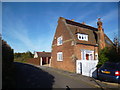
The lower lodge to Hitcham House (to which the drive leads), on Hitcham Road.
Image: © Derek Harper
Taken: 19 Nov 2010
0.14 miles
6
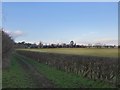
Farmland, seen from Boundary Road
The view is in the general direction of Hitcham.
Image: © Stefan Czapski
Taken: 13 Jan 2014
0.17 miles
7

Housing near Lent Rise
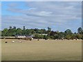
The housing on Hanbury Close consists of short terraces; these, at right angles to the close, back onto countryside. The more distant housing is on Milner Road and Lent Rise Road.
Image: © Derek Harper
Taken: 19 Nov 2010
0.18 miles
8
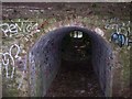
Strange little tunnel
The footpath passes through this strange little tunnel / bridge, that naturally has attracted a fair amount of graffiti.
Image: © Balraj Gill
Taken: 20 Sep 2008
0.19 miles
9
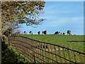
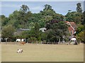
Cows in Hitcham Park
This is shaded as parkland on the map although to look at it's no different from any other fields.
But the access bridges over the footpath, as in Image and this elaborate iron fence give hints of an old estate.
Image: © Des Blenkinsopp
Taken: 15 Nov 2013
0.20 miles