IMAGES TAKEN NEAR TO
Ferrers Close, SLOUGH, SL1 5TS
Introduction
This page details the photographs taken nearby to Ferrers Close, SL1 5TS by members of the Geograph project.
The Geograph project started in 2005 with the aim of publishing, organising and preserving representative images for every square kilometre of Great Britain, Ireland and the Isle of Man.

There are currently over 7.5m images from over14,400 individuals and you can help contribute to the project by visiting https://www.geograph.org.uk
Image Map
Images are licensed for reuse under creativecommons.org/licenses/by-sa/2.0
Notes
- Clicking on the map will re-center to the selected point.
- The higher the marker number, the further away the image location is from the centre of the postcode.
Image Listing (11 Images Found)
Images are licensed for reuse under creativecommons.org/licenses/by-sa/2.0
Image
Details
Distance
1

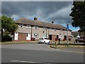
Cippenham Community Centre
This large purpose-built community centre is in Earls Lane.
The odd vertical cloud formation behind the roof is emanating from one of the cooling towers at Image
Image: © Nigel Cox
Taken: 8 Jan 2009
0.15 miles
2
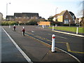
Cippenham: Richards Way
There is a novel twist to the humble bollard outside Western House Primary School...
Image: © Nigel Cox
Taken: 8 Jan 2009
0.16 miles
3
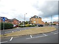
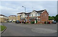
Cippenham - Hunters Way
Modern housing estate.
Image: © James Emmans
Taken: 24 Jun 2017
0.16 miles
6
Cippenham - Houses on Lower Cippenham Lane
Image: © James Emmans
Taken: 24 Jun 2017
0.21 miles
7
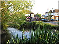
Cippenham Green
The only ancient village green left within the boundaries of Slough. This photo shows the adjacent duck pond and two of the three public houses which surround the green.
Image: © Darren Smith
Taken: 8 Jun 2005
0.23 miles
8
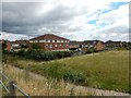
Cippenham - Housing Estate next to the M4
Image: © James Emmans
Taken: 24 Jun 2017
0.23 miles
10
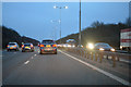
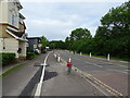
Slough : M4 Motorway
The M4 Motorway between Junction 7 (Huntercombe Spur) and Junction 6 (Tuns Lane).
Image: © Lewis Clarke
Taken: 23 Mar 2018
0.24 miles