IMAGES TAKEN NEAR TO
Mercian Way, SLOUGH, SL1 5LX
Introduction
This page details the photographs taken nearby to Mercian Way, SL1 5LX by members of the Geograph project.
The Geograph project started in 2005 with the aim of publishing, organising and preserving representative images for every square kilometre of Great Britain, Ireland and the Isle of Man.

There are currently over 7.5m images from over14,400 individuals and you can help contribute to the project by visiting https://www.geograph.org.uk
Image Map
Images are licensed for reuse under creativecommons.org/licenses/by-sa/2.0
Notes
- Clicking on the map will re-center to the selected point.
- The higher the marker number, the further away the image location is from the centre of the postcode.
Image Listing (26 Images Found)
Images are licensed for reuse under creativecommons.org/licenses/by-sa/2.0
Image
Details
Distance
1

Table Tennis, Mercian Way Park
A recreation ground on the edge of Slough next to the M4.
Image: © Des Blenkinsopp
Taken: 19 Feb 2019
0.10 miles
2

Mercian Way Park
A recreation ground on the edge of town next to the M4.
Image: © Des Blenkinsopp
Taken: 19 Feb 2019
0.10 miles
4

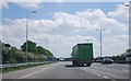
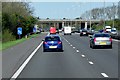
Fellow-travellers on the M4 eastbound south of Burnham
Image: © Robin Stott
Taken: 10 Jul 2013
0.15 miles
6
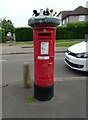
Yarn bombed George VI postbox on Harrison Way, Slough
Postbox No. SL1 224.
Image: © JThomas
Taken: 25 May 2022
0.16 miles
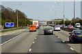
7

Slough : M4 Motorway
The M4 Motorway between Junction 7 (Huntercombe Spur) and Junction 6 (Tuns Lane).
Image: © Lewis Clarke
Taken: 23 Mar 2018
0.16 miles