IMAGES TAKEN NEAR TO
Swift Close, SLOUGH, SL1 5FT
Introduction
This page details the photographs taken nearby to Swift Close, SL1 5FT by members of the Geograph project.
The Geograph project started in 2005 with the aim of publishing, organising and preserving representative images for every square kilometre of Great Britain, Ireland and the Isle of Man.

There are currently over 7.5m images from over14,400 individuals and you can help contribute to the project by visiting https://www.geograph.org.uk
Image Map
Images are licensed for reuse under creativecommons.org/licenses/by-sa/2.0
Notes
- Clicking on the map will re-center to the selected point.
- The higher the marker number, the further away the image location is from the centre of the postcode.
Image Listing (10 Images Found)
Images are licensed for reuse under creativecommons.org/licenses/by-sa/2.0
Image
Details
Distance
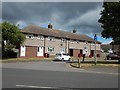
2
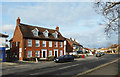
Lower Cippenham Lane
Swan Place in the foreground looks like an old pub converted to housing.
Image: © Des Blenkinsopp
Taken: 19 Feb 2019
0.17 miles
5
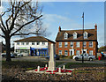
Cippenham War Memorial
In the background is Swan Place, looking like a former pub converted to housing.
Image: © Des Blenkinsopp
Taken: 19 Feb 2019
0.20 miles
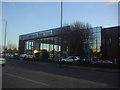
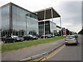
6
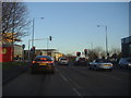
Bath Road at the junction of Cippenham Lane
Entering the Slough industrial park
Image: © David Howard
Taken: 19 Feb 2012
0.20 miles
7
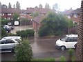
Corfe Gardens
Residential estate off Cippenham Lane.
Image: © Balraj Gill
Taken: 10 Sep 2005
0.22 miles
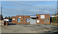
8
Cippenham - Houses on Lower Cippenham Lane
Image: © James Emmans
Taken: 24 Jun 2017
0.23 miles
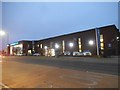
10
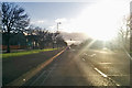
The morning sun breaks through over Slough
On the A4 Bath Road heading east.
Image: © Robin Webster
Taken: 7 Jan 2018
0.24 miles