IMAGES TAKEN NEAR TO
Eltham Avenue, SLOUGH, SL1 5AF
Introduction
This page details the photographs taken nearby to Eltham Avenue, SL1 5AF by members of the Geograph project.
The Geograph project started in 2005 with the aim of publishing, organising and preserving representative images for every square kilometre of Great Britain, Ireland and the Isle of Man.

There are currently over 7.5m images from over14,400 individuals and you can help contribute to the project by visiting https://www.geograph.org.uk
Image Map
Images are licensed for reuse under creativecommons.org/licenses/by-sa/2.0
Notes
- Clicking on the map will re-center to the selected point.
- The higher the marker number, the further away the image location is from the centre of the postcode.
Image Listing (23 Images Found)
Images are licensed for reuse under creativecommons.org/licenses/by-sa/2.0
Image
Details
Distance

5
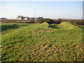
Cippenham Moat (2)
The earthworks that create this dry moat are all that remains of the site of a Royal Palace of King Henry III (1207 - 1272), who reigned for fifty six years from 1216 until his death. The workings middle right may have been a ramp up to the main palace entrance.
Image: © Nigel Cox
Taken: 8 Jan 2009
0.16 miles
6
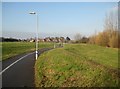
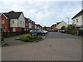
Cippenham: Little Chapels Way Open Space
The open space is between Cippenham and the ASDA superstore in Cippenham Meadows. Any explanation as to the naming of it would be welcome!
Image: © Nigel Cox
Taken: 8 Jan 2009
0.16 miles
7

Remains of Henry's Palace
Extensive earthworks mark the site of a 13th century royal palace belonging to King Henry 3rd.
https://en.wikipedia.org/wiki/Cippenham_Moat
Image: © Des Blenkinsopp
Taken: 19 Feb 2019
0.18 miles
8
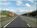
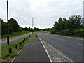
M4 north of Slough Sewage Treatment Works
On warm summer days, this is a stretch of the M4 that is best driven with car windows shut and a/c on!
Image: © Stuart Logan
Taken: 11 Apr 2013
0.19 miles
9
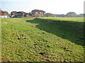
Cippenham Moat (1)
The earthworks that create this dry moat are all that remains of the site of a Royal Palace of King Henry III (1207 - 1272), who reigned for fifty six years from 1216 until his death. In the distance are the houses on the Cippenham Meadows estate.
Image: © Nigel Cox
Taken: 8 Jan 2009
0.20 miles
10

Cippenham Moat
The remains of a 13th century royal palace belonging to King Henry 3rd. Substantial earthworks in a field between housing and an Asda store.
https://en.wikipedia.org/wiki/Cippenham_Moat
Image: © Des Blenkinsopp
Taken: 19 Feb 2019
0.20 miles