IMAGES TAKEN NEAR TO
Bath Road, SLOUGH, SL1 4AA
Introduction
This page details the photographs taken nearby to Bath Road, SL1 4AA by members of the Geograph project.
The Geograph project started in 2005 with the aim of publishing, organising and preserving representative images for every square kilometre of Great Britain, Ireland and the Isle of Man.

There are currently over 7.5m images from over14,400 individuals and you can help contribute to the project by visiting https://www.geograph.org.uk
Image Map
Images are licensed for reuse under creativecommons.org/licenses/by-sa/2.0
Notes
- Clicking on the map will re-center to the selected point.
- The higher the marker number, the further away the image location is from the centre of the postcode.
Image Listing (15 Images Found)
Images are licensed for reuse under creativecommons.org/licenses/by-sa/2.0
Image
Details
Distance
1

Twinches Lane Retail Park
A retail park with large shops and extensive car parking in Slough.
Image: © Oscar Taylor
Taken: 20 May 2023
0.04 miles
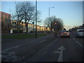
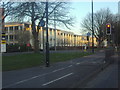
2
Bath Road, Slough, overlooking the DFS Furniture shop
Image: © David Howard
Taken: 19 Feb 2012
0.04 miles
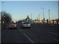
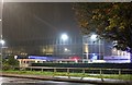
3
Lights on Bath Road, Slough
At the junction of Twinches Lane
Image: © David Howard
Taken: 19 Feb 2012
0.05 miles
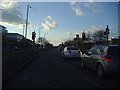
4
Bath Road, Slough
Driving through the modern industrial area
Image: © David Howard
Taken: 19 Feb 2012
0.05 miles
5

Slough Retail Park, Twinches Lane
Just off the A4 Bath Road which runs through the middle of the square, this photo is looking south.
Image: © Darren Smith
Taken: 7 Jun 2005
0.05 miles
6
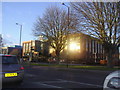
Black and Decker offices on Bath Road, Slough
Image: © David Howard
Taken: 19 Feb 2012
0.07 miles
8
Guru Maneyo Granth Gurdwara
A Sikh temple in a rainstorm
Image: © David Howard
Taken: 12 Oct 2019
0.11 miles
9
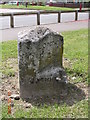
Old Milestone by the A4, Bath Road, Slough
Carved stone post by the A4, in parish of Slough (Slough District), Bath Road; East of junction with Leigh Road, on wide well cut grass verge between main road and cycle track, on South side of road. Bath Road limestone diamond, erected by the Colnbrook, Datchet & Slough turnpike trust in the 18th century.
Inscription reads:-
: MAIDENHEAD / 4 : : LONDON / 22 : : SLOUGH / 1 :
Grade II listed.
List Entry Number: 1113373 https://historicengland.org.uk/listing/the-list/list-entry/1113373
Milestone Society National ID: BU_LB22
Image: © A Rosevear & J Higgins
Taken: 9 Jul 2001
0.13 miles
10
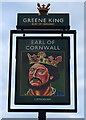
Sign for the Earl of Cornwall, Slough
See Image] for public house.
Image: © JThomas
Taken: 25 May 2022
0.16 miles