IMAGES TAKEN NEAR TO
North Green, SLOUGH, SL1 3RD
Introduction
This page details the photographs taken nearby to North Green, SL1 3RD by members of the Geograph project.
The Geograph project started in 2005 with the aim of publishing, organising and preserving representative images for every square kilometre of Great Britain, Ireland and the Isle of Man.

There are currently over 7.5m images from over14,400 individuals and you can help contribute to the project by visiting https://www.geograph.org.uk
Image Map
Images are licensed for reuse under creativecommons.org/licenses/by-sa/2.0
Notes
- Clicking on the map will re-center to the selected point.
- The higher the marker number, the further away the image location is from the centre of the postcode.
Image Listing (13 Images Found)
Images are licensed for reuse under creativecommons.org/licenses/by-sa/2.0
Image
Details
Distance
1
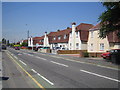
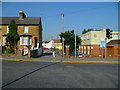
Slough: Elliman Avenue
Home of a housing estate with unusual houses built with their chimneys at the front, Elliman Avenue is named after one of Slough's municipal benefactors, James Elliman (yes, he of Elliman's Embrocation fame). Some houses along the road, such as the salmon-coloured one on the right side of the photo, have had their chimneys removed.
Image: © Nigel Cox
Taken: 19 Jul 2006
0.15 miles
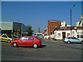
3

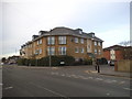
Elliman Avenue
The rear carpark entrance to the JMIC Slough is to the far left. The mosque minarets can be seen; these help worshippers recognise where the mosque is located, especially in complex urban settings.
The mosque was converted from a Welsh Congregational Church in 1982. Over a long time the Welsh immigrants would have slowly been replaced by Muslim immigrants and the need for a mosque grew.
Image: © James Emmans
Taken: 19 Jun 2021
0.17 miles

6
Orange Way after Wiltshire (462)
Here the view is across Stoke Road into Littledown Road.
Image: © Shazz
Taken: 4 Sep 2013
0.23 miles
7
Orange Way after Wiltshire (461)
This view along Stoke Gardens ends at the tall chimney on the GlaxoSmithKline site.
Image: © Shazz
Taken: 4 Sep 2013
0.24 miles
8
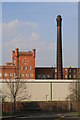
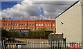
Horlicks Factory
My own view of an iconic factory. The chimney is particularly fine and I couldn't resist an early evening detour to get some views of this.
Image: © Chris Allen
Taken: 8 Apr 2007
0.24 miles
9
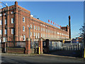
Horlicks factory, Slough
A locally listed building, completed 1908 and still operational.
Image: © Robin Webster
Taken: 19 Jan 2014
0.24 miles