IMAGES TAKEN NEAR TO
Summerlea, SLOUGH, SL1 2YH
Introduction
This page details the photographs taken nearby to Summerlea, SL1 2YH by members of the Geograph project.
The Geograph project started in 2005 with the aim of publishing, organising and preserving representative images for every square kilometre of Great Britain, Ireland and the Isle of Man.

There are currently over 7.5m images from over14,400 individuals and you can help contribute to the project by visiting https://www.geograph.org.uk
Image Map
Images are licensed for reuse under creativecommons.org/licenses/by-sa/2.0
Notes
- Clicking on the map will re-center to the selected point.
- The higher the marker number, the further away the image location is from the centre of the postcode.
Image Listing (12 Images Found)
Images are licensed for reuse under creativecommons.org/licenses/by-sa/2.0
Image
Details
Distance
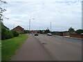
2
Earl of Cornwall, Slough
On Cippenham Lane.
See Image] for sign.
Image: © JThomas
Taken: 25 May 2022
0.10 miles
3
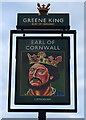
Sign for the Earl of Cornwall, Slough
See Image] for public house.
Image: © JThomas
Taken: 25 May 2022
0.11 miles
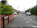
6
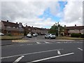
Slough - Entrance to Cress Road
Junction with Keel Drive.
Image: © James Emmans
Taken: 24 Jun 2017
0.17 miles
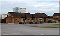
8
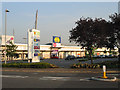
Slough Retail Park, Twinches Lane
Just off the A4 Bath Road which runs through the middle of the square, this photo is looking south.
Image: © Darren Smith
Taken: 7 Jun 2005
0.19 miles
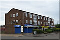
9
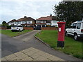
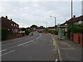
Houses on Cippenham Lane, Slough
Showing position of Postbox No. SL1 206.
See Image] for postbox.
Image: © JThomas
Taken: 25 May 2022
0.21 miles
10
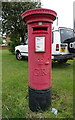
George V postbox on Cippenham Lane, Slough
Postbox No. SL1 206.
See Image] for context.
Image: © JThomas
Taken: 25 May 2022
0.23 miles