1
The future is bright for Chalvey, Slough
The Slough Borough Council banner is at the SE entrance to Chalvey Recreation Ground,
near the corner of High Street and Ladbrooke Road.
Image: © Jaggery
Taken: 27 Apr 2013
0.02 miles
2
YMCA, Slough
Large hostel in the Chalvey district of Slough.
Image: © Des Blenkinsopp
Taken: 19 Feb 2019
0.06 miles
3
Slough YMCA, Chalvey, Slough
The YMCA building at 30 Ladbrooke Road provides housing for 45 single people.
Slough YMCA, working in partnership with Slough Borough Council’s Housing Needs department and Supporting People Team, is one of the largest providers of temporary housing in Slough. Residents can stay for up to 2 years.
Image: © Jaggery
Taken: 27 Apr 2013
0.07 miles
4
Slough : Berskhire Scenery
Looking across Berkshire with the M4 Motorway and Jubilee River in view.
Image: © Lewis Clarke
Taken: 5 Jan 2017
0.08 miles
5
A355, northbound
Image: © N Chadwick
Taken: 6 Jun 2015
0.09 miles
6
Ladbrooke Road shops, Chalvey, Slough
Viewed from High Street, Chalvey. On the left is Trade Price Beds. On the right is the Roti and Curry Hut.
Image: © Jaggery
Taken: 27 Apr 2013
0.09 miles
7
Children's play area, Chalvey Recreation Ground, Slough
The play area is at the eastern edge of the recreation ground.
Image: © Jaggery
Taken: 27 Apr 2013
0.09 miles
8
High Street Shops, Chalvey
High Streets are usually at the centre of their districts, but Chalvey High Street isn't typical. Lined with a random selection of suburban housing and business park type developments, it's more of a road to somewhere else.
Image: © Des Blenkinsopp
Taken: 19 Feb 2019
0.10 miles
9
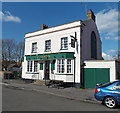
Garibaldi, Chalvey, Slough
The pub at 6 The Green, Chalvey, is an interesting mixture. Its name appears to commemorate the 19th century Italian general and politician Giuseppe Garibaldi, a founding father of unified Italy,
yet the green colours and style of lettering on the pub suggest a connection with Ireland.
Image: © Jaggery
Taken: 27 Apr 2013
0.14 miles
10
The Green, Chalvey
Image: © Des Blenkinsopp
Taken: 19 Feb 2019
0.15 miles


