IMAGES TAKEN NEAR TO
Spackmans Way, SLOUGH, SL1 2SD
Introduction
This page details the photographs taken nearby to Spackmans Way, SL1 2SD by members of the Geograph project.
The Geograph project started in 2005 with the aim of publishing, organising and preserving representative images for every square kilometre of Great Britain, Ireland and the Isle of Man.

There are currently over 7.5m images from over14,400 individuals and you can help contribute to the project by visiting https://www.geograph.org.uk
Image Map
Images are licensed for reuse under creativecommons.org/licenses/by-sa/2.0
Notes
- Clicking on the map will re-center to the selected point.
- The higher the marker number, the further away the image location is from the centre of the postcode.
Image Listing (32 Images Found)
Images are licensed for reuse under creativecommons.org/licenses/by-sa/2.0
Image
Details
Distance
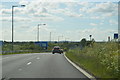
1
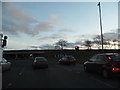
Roundabout for the M4, Chalvey
Straight ahead for Windsor
Image: © David Howard
Taken: 8 Mar 2015
0.11 miles
2
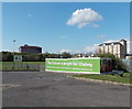
The future is bright for Chalvey, Slough
The Slough Borough Council banner is at the SE entrance to Chalvey Recreation Ground,
near the corner of High Street and Ladbrooke Road.
Image: © Jaggery
Taken: 27 Apr 2013
0.12 miles
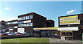
3

YMCA, Slough
Large hostel in the Chalvey district of Slough.
Image: © Des Blenkinsopp
Taken: 19 Feb 2019
0.12 miles
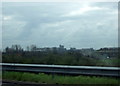
4
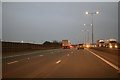
Slough : M4 Motorway
The M4 Motorway between Junction 6 (Tuns Lane) and Junction 5 (Langley Roundabout).
Image: © Lewis Clarke
Taken: 23 Mar 2018
0.13 miles
5

Slough YMCA, Chalvey, Slough
The YMCA building at 30 Ladbrooke Road provides housing for 45 single people.
Slough YMCA, working in partnership with Slough Borough Council’s Housing Needs department and Supporting People Team, is one of the largest providers of temporary housing in Slough. Residents can stay for up to 2 years.
Image: © Jaggery
Taken: 27 Apr 2013
0.14 miles
6
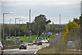
Windsor and Maidenhead : M4 Motorway Junction 6
Heading off of Junction 6 of the M4 Motorway.
Image: © Lewis Clarke
Taken: 26 Oct 2014
0.14 miles
8
Ladbrooke Road shops, Chalvey, Slough
Viewed from High Street, Chalvey. On the left is Trade Price Beds. On the right is the Roti and Curry Hut.
Image: © Jaggery
Taken: 27 Apr 2013
0.15 miles
9

High Street Shops, Chalvey
High Streets are usually at the centre of their districts, but Chalvey High Street isn't typical. Lined with a random selection of suburban housing and business park type developments, it's more of a road to somewhere else.
Image: © Des Blenkinsopp
Taken: 19 Feb 2019
0.15 miles
10
M4 view of Windsor Castle
Taken from a moving vehicle (you wouldn't want to be up here on foot) but a rare view of the royal residence from the M4 flyover north of Windsor: blink and you miss it.
Image: © Natasha Ceridwen de Chroustchoff
Taken: 18 Mar 2008
0.16 miles