IMAGES TAKEN NEAR TO
Kings Road, SLOUGH, SL1 2PT
Introduction
This page details the photographs taken nearby to Kings Road, SL1 2PT by members of the Geograph project.
The Geograph project started in 2005 with the aim of publishing, organising and preserving representative images for every square kilometre of Great Britain, Ireland and the Isle of Man.

There are currently over 7.5m images from over14,400 individuals and you can help contribute to the project by visiting https://www.geograph.org.uk
Image Map
Images are licensed for reuse under creativecommons.org/licenses/by-sa/2.0
Notes
- Clicking on the map will re-center to the selected point.
- The higher the marker number, the further away the image location is from the centre of the postcode.
Image Listing (46 Images Found)
Images are licensed for reuse under creativecommons.org/licenses/by-sa/2.0
Image
Details
Distance
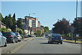
1
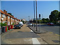
Orange Way after Wiltshire (458)
The route continues on Windsor Road (the A332).
Image: © Shazz
Taken: 4 Sep 2013
0.06 miles
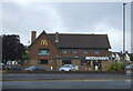
8
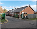
Slough Bowls Club
Viewed from Botham Drive. Formed in 1911, Slough Bowls Club has been at this site since 2000.
In view is the clubhouse located between Chalvey Road East and the northern end of the bowling green.
Slough Bowls Club is a lawn and shortmat bowls club.
Image: © Jaggery
Taken: 27 Apr 2013
0.13 miles
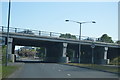
9
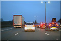
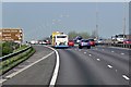
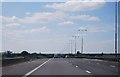
Slough : M4 Motorway
The M4 Motorway between Junction 6 (Tuns Lane) and Junction 5 (Langley Roundabout).
Image: © Lewis Clarke
Taken: 23 Mar 2018
0.13 miles