IMAGES TAKEN NEAR TO
Upton Park, SLOUGH, SL1 2DG
Introduction
This page details the photographs taken nearby to Upton Park, SL1 2DG by members of the Geograph project.
The Geograph project started in 2005 with the aim of publishing, organising and preserving representative images for every square kilometre of Great Britain, Ireland and the Isle of Man.

There are currently over 7.5m images from over14,400 individuals and you can help contribute to the project by visiting https://www.geograph.org.uk
Image Map
Images are licensed for reuse under creativecommons.org/licenses/by-sa/2.0
Notes
- Clicking on the map will re-center to the selected point.
- The higher the marker number, the further away the image location is from the centre of the postcode.
Image Listing (52 Images Found)
Images are licensed for reuse under creativecommons.org/licenses/by-sa/2.0
Image
Details
Distance
1
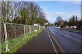
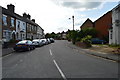
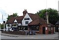
Albert Street, Slough
Albert Street has been closed to through traffic, leaving The Wheatsheaf pub and a few shops facing onto a quiet cul de sac.
Image: © Des Blenkinsopp
Taken: 30 Oct 2017
0.08 miles
2
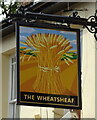
Sign for the Wheatsheaf, Slough
See Image] for context.
Image: © JThomas
Taken: 23 May 2022
0.08 miles
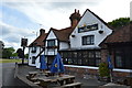
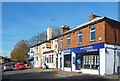
3
The Wheatsheaf, Slough
On Albert Street.
See Image] for sign.
Image: © JThomas
Taken: 23 May 2022
0.08 miles
5
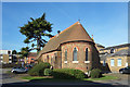
St Andrew's Chapel, Upton Hospital
I can't find much information about the chapel. It's no longer shown as a Place of Worship on the map.
Image: © Des Blenkinsopp
Taken: 30 Oct 2017
0.11 miles