IMAGES TAKEN NEAR TO
Parkside Walk, SLOUGH, SL1 2BL
Introduction
This page details the photographs taken nearby to Parkside Walk, SL1 2BL by members of the Geograph project.
The Geograph project started in 2005 with the aim of publishing, organising and preserving representative images for every square kilometre of Great Britain, Ireland and the Isle of Man.

There are currently over 7.5m images from over14,400 individuals and you can help contribute to the project by visiting https://www.geograph.org.uk
Image Map
Images are licensed for reuse under creativecommons.org/licenses/by-sa/2.0
Notes
- Clicking on the map will re-center to the selected point.
- The higher the marker number, the further away the image location is from the centre of the postcode.
Image Listing (53 Images Found)
Images are licensed for reuse under creativecommons.org/licenses/by-sa/2.0
Image
Details
Distance
1
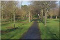
Path across Lascelles Playing Field
Path across the edge of the playing field seen from Upton Court Road.
Image: © Stephen McKay
Taken: 12 Dec 2011
0.06 miles
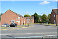
3
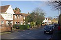
Upton Road, Slough
Suburban housing within easy walking distance of Slough town centre.
Image: © Stephen McKay
Taken: 12 Dec 2011
0.08 miles

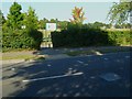
7

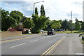
Upton Court Road approaching the Red Cow Roundabout
Image: © Shazz
Taken: 4 Sep 2013
0.09 miles
8
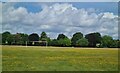
Football pitch in Lascelles Playing Fields
Image: © Rod Allday
Taken: 25 Jun 2022
0.10 miles
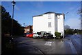
10
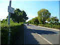
Upton Court Road looking west
The notice on the left seems pointless, there being no mown verge.
Image: © Shazz
Taken: 4 Sep 2013
0.12 miles