IMAGES TAKEN NEAR TO
The Observatory, High Street, SLOUGH, SL1 1LN
Introduction
This page details the photographs taken nearby to The Observatory, High Street, SL1 1LN by members of the Geograph project.
The Geograph project started in 2005 with the aim of publishing, organising and preserving representative images for every square kilometre of Great Britain, Ireland and the Isle of Man.

There are currently over 7.5m images from over14,400 individuals and you can help contribute to the project by visiting https://www.geograph.org.uk
Image Map
Images are licensed for reuse under creativecommons.org/licenses/by-sa/2.0
Notes
- Clicking on the map will re-center to the selected point.
- The higher the marker number, the further away the image location is from the centre of the postcode.
Image Listing (79 Images Found)
Images are licensed for reuse under creativecommons.org/licenses/by-sa/2.0
Image
Details
Distance
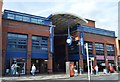
4
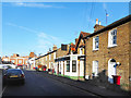
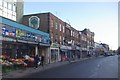
Alpha Road North
Featuring the Alpha Arms pub and Thai Kitchen.
Image: © Des Blenkinsopp
Taken: 30 Oct 2017
0.04 miles
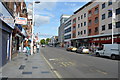
9
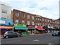
High Street, Slough
Showing the eastern end of the High Street with the Marwa Superstore on the left.
Image: © Stephen McKay
Taken: 12 Dec 2011
0.06 miles